Sunday, March 31, 2019

Anniversary Weekend 2019 part 2: the Road to Nowhere - Tunnel Bypass Trail and Goldmine Loop Trail

New Miles Completed: 4.3
Total Miles Hiked: 5.3
31 March 2019

On the final day of our anniversary getaway weekend we opted to head out to the end of the Road to Nowhere and hike the trails around it. I've heard of this place forever: the promise to build a road to follow the northern shore of Fontana Lake after Fontana Dam was built, the delays, the lack of funds, the lawsuits... Ultimately the road was never completed. Fontana Road runs west from Bryson City in to the GSMNP where it becomes Lakeview Drive, it reaches a tunnel, and then stops.

View of Fontana Lake from Lakeview Drive

Parking lot / Trailhead for Lakeshore Trail at the end of Lakeview Drive


Super creepy / super cool tunnel that you have to walk through. Sadly, LOTS of graffiti on the walls.
Our goal for the day was to do a double loop that included both the Tunnel Bypass trail and the Goldmine Loop trail. From the trailhead, through the tunnel, and to the Tunnel Bypass trail junction is about 0.6 miles. At the Tunnel Bypass trail we turned left onto the Tunnel Bypass trail, and back toward where we had just parked.

Lakeshore Trail / Tunnel Bypass trail junction

Tunnel Bypass Trail

Views of surrounding ridges from the Tunnel Bypass Trail
The Tunnel Bypass Trail is a narrow, single-track ridge-side walk that skirts the edge of the ridge that the tunnel goes through. It dives south from the Lakeshore Trail, then back east toward the parking lot, then finally north back to the parking lot. Not a lot to say about this trail - it's on a dry, south-facing slope with a fairly steep aspect. Lots of mountain laurel and pine. Nice views of the surrounding ridges this time of year because the leaves are all off the trees.

At mile 1.2 of the Tunnel Bypass trail you arrive at its junction with the Goldmine Loop trail. To complete all of the trail sections we hiked the 0.4 miles from here down to the parking lot, then turned around and hiked the 0.4 miles back up to this junction to begin the Goldmine Loop trail.

Tunnel Bypass trail / Goldmine Loop trail junction

End of the Tunnel Bypass trail at the parking lot.
Goldmine Loop trail makes a big loop from the tunnel down to an inlet of Fontana Lake and then back up the other side. On the west side it follows Goldmine Branch, and on the east side it follows Tunnel Branch. The trail drops steeply from its junction with the Tunnel Bypass trail.

Goldmine Loop trail
As the trail drops through the upper parts of the ridge that are dry and mostly mountain laurel and pine, it hooks up with Tunnel Branch and begins to flatten out and form the long green tunnel of Rhododendron and Laurel. The trail follows the creek until the creek empties out into an inlet of Fontana Lake. This time of year the water has been drawn down, so the edges of the lake are considerably lower than they will be in summer, and a long muddy flat exists at the end of the inlet.

Fontana Lake inlet on Goldmine Loop trail
From here the trail follows Goldmine Branch, climbing slowly and easily along the creek. It passes backcountry campsite #67 that we declined to investigate (because it was up just one more hill...), and slogs through several mucky areas where small creeks and seeps are spilling in to Goldmine Creek. In several of these spots boards have been installed to facilitate travel above the muck.

Walking boards to avoid the muck
As the trail follows Goldmine Branch it's clear that the southern bank of the creek was settled. There are many flat-ish spots that would make great home sites, and you can still find rusty metal buckets, sections of fence, and piles of chimney stones. It's always fun to imagine what the lives of the folks who lived in this place were like.

Pile of chimney stones along the south side of Goldmine Branch
From here the trail begins to rise back up the ridge toward Lakeshore Trail. And it does so fairly steeply. This section isn't long - maybe 1/3 mile, but it is pretty steep going up.

The last push up Goldmine Loop trail back to the Lakeshore Trail
From here we re-traced our steps back along the Lakeshore Trail to, and through the tunnel to our car. It was a fun loop - the descent and ascent on Goldmine Loop were a bit challenging, but the chance to see the end of the Road to Nowhere and walk through the tunnel, the Fontana Lake inlet, and the old homesites along Goldmine Branch were all really cool. This pair of loops was more fun than I anticipated it would be! Always great to be out in the Smokies.

Back side of the tunnel.

Stopped to get our picture at the park entrance sign!
Hope everyone is enjoying spring and making big plans for hiking this summer!

Til next time, happy hiking.

Anniversary Weekend 2019 part 1: Deep Creek Waterfalls Loop

New Miles Completed: 2.5
Total Miles Hiked: 5.7
29 March 2019

Sarah and I try to get away for a weekend every year around our anniversary. We usually get a cabin somewhere around the Smokies and go for a hike or two. This year we chose to stay in Bryson City, NC at a really nice little cabin. On Saturday March 29th we did some trails around the Deep Creek area.

Deep Creek trails

The Deep Creek section in and around the campground are kind of a warren of trails connecting the main trails and the parking lots and the side trails... The trails traced in red are what we did, but there were at least a few other "trails" that we did to make sure we didn't miss anything important.

Started out at the horse parking lot at the Noland Divide trailhead near the entrance to Deep Creek campground. After just a 100 feet or so the Deep Creek Horse trail turns right (north).

Noland Divide trailhead at Deep Creek campground

Deep Creek Horse Trail beginning
Deep Creek Horse Trail parallels the road into Deep Creek Campground on the ridge to the west of, and above the road. In spite of being a horse trail, it's in pretty good shape. After just about a mile you reach the side trail to Juney Whank Falls. This is a really nice cascade with a neat wooden bridge that spans the creek at the falls, complete with wooden benches.

Juney Whank Falls
The trails kind of makes a circle around Juney Whank Falls: Deep Creek Horse Trail going above the falls, and meeting up with the Juney Whank Trail that goes down to the parking lot. So after walking the short trail at the falls, we went back up and did the trail above the falls. Then we did the trail down to the parking lot. Then we did the trail back up from the parking lot... A bunch of backtracking!

Some of the trail signs around the Deep Creek Horse Trail / Juney Whank Trail
After completing this somewhat confusing chunk, we headed on up the Deep Creek Horse trail. Near the northern end of the horse trail is a sign that says "Cemetery" and points up a manway along Hammer Creek. We figured "here we are, what the heck!" so we headed up the trail. And I do mean UP! The trail is not long (graffiti on the cemetery sign says 0.7 miles), but it is straight up hill! The cemetery at the top is called the Hammer Creek Cemetery or the Wiggins Cemetery and apparently contains the graves of 5 Wiggins children. Three of the graves are marked with recent stones, while the other two unmarked. Sad to imagine a family losing 5 children! Needless to say, the hike back down went much faster than the hike up...

Side trail to Hammer Branch cemetery

Bloodroot (Sanguinaria canadensis) - one of the earliest spring wildflowers
Shortly after the cemetery side trail we reached the end of the Deep Creek Horse trail at its junction with the Deep Creek trail. This junction must have been an old home site - there was Forsythia and Flowering Quince growing here, both of which are non-native but oft-planted ornamentals. I had previously done Deep Creek all the way from Newfound Gap Road all the way down to the campground with the Annual Spring Wildflower Pilgrimage.

Trail signs at the Deep Creek Horse trail / Deep Creek trail junction
 From here we headed back down toward the campground along the Deep Creek trail. At the junction with Indian Creek trail we turned east on to Indian Creek trail to see Indian Creek Falls. We followed this trail 0.5 miles til it reached the junction with Stone Pile Gap trail, and then turned around.

Deep Creek trail / Indian Creek trail junction

Indian Creek Falls
Indian Creek Falls was absolutely gorgeous! I was beginning to understand why this Deep Creek waterfall loop was so popular! And popular it was on this beautiful spring Saturday. LOTS of families out hiking, several of them with their dogs. Grrr. [pets are not allowed in the backcountry except on 2 trails: Gatlinburg trail and Oconaluftee River trail]. This trail is apparently one of the trails that allows bikes (it's an old gravel road), so there were many bikers out as well!

Deep Creek trail follows its namesake, which is a wide and beautiful creek. Along the way it passes the 3rd beautiful cascade - Tom Branch Falls, complete with wooden benches to sit and view the waterfall from.

Beautiful Deep Creek

Tom Branch Falls
 Shortly thereafter the trail empties out at the northern end of the Deep Creek Campground. It was a lovely day with sun and warm temperatures, and lots of really nice creeks and waterfalls to enjoy. The Deep Creek waterfall loop is definitely worth a visit, but do be prepared for crowds if the weather is good.

End of the line: Deep Creek trailhead at Deep Creek campground
Stay tuned for the next day's hike! Road to Nowhere.

Til next time, happy hiking!

Saturday, March 23, 2019

Smokemont Loop - Bradley Fork - Cabin Flats - Dry Sluice Gap - Bradley Fork - Hughes Ridge - Chasteen Creek - Bradley Fork Spring Break Backpack

New Miles Completed: 24.3
Total Miles Hiked: 32.6
3 day / 2 night backpack, 20-22 March 2019

It's been a long time since I've added any new trail miles to the quest. Took advantage of Spring Break to get in a backpack out of Smokemont campground to do a few new trails and make some connections with prior hikes.

Day 1: Smokemont Campground to Cabin Flats backcountry campsite #49.
Arrived at Smokemont Campground around 1 pm. Had a hard time figuring out where to park near the Smokemont Loop trailhead - there don't seem to be any designated parking spaces for hikers. Ended up parking in the extra spaces for the campground loop A. My car was still there when I got back, so I guess it was ok.

Smokemont Loop trail starts out on a bridge over the Oconaluftee River, and then follows an old road for a bit. Pretty quickly it leaves the old road, and turns off to the right and uphill.

At the Smokemont Loop trailhead

Beginning of the Smokemont Loop trail. Sign @ junction where the trail rises into the woods.
Smokemont Loop trail gains elevation steadily over the first couple of miles, rising about 1400 feet from the trailhead. The trail alternates between a green tunnel of Rhododendron and Mountain Laurel, and open ridge-side trail. One of the things I enjoy about winter/early spring hiking is the openness of the woods before the trees all leaf out. Apparently I missed the side trail to the Bradley Cemetery that's near the beginning of this trail... Bummer. After you reach the crest and turn a corner, it's all downhill til you cross the Bradley Fork on a long log bridge, and find yourself at the junction with the Bradley Fork trail. 

Bradley Fork bridge

Early spring wildflower: Liverleaf (Hepatica)

Smokemont Loop - Bradley Fork trail junction
Because I was ultimately making a big loop, and there is a 0.5 mile section of the Bradley Fork trail that I would miss, I did a quick out and back to the Chasteen Creek - Bradley Fork trail junction.

From there I headed up the Bradley Fork trail toward Cabin Flats. Bradley Fork trail is an old road that follows the creek gently up the valley. Bradley Fork is a beautiful creek, and it was running full and fast. Lots of nice little waterfalls running into it from the sides.

Bradley Fork trail - a nice wide old roadbed

Bradley Fork

Cascade running into the Bradley Fork
Bradley Fork runs into the Cabin Flats trail at an old road turnaround. At this point the Bradley Fork trail takes a hard right to rise up toward Hughes Ridge, while Cabin Flats trail continues straight toward its junction with Dry Sluice Gap trail. I took the Cabin Flats trail out to its end at Campsite #49 - Cabin Flats, which would be my home for the next 2 nights.

Cool old bridge on Cabin Flats trail

Cabin Flats - Dry Sluice Gap trail junction
Campsite #49 is really nice. It's a wide, flat plain along the Cabin Branch. The campsite is open to hikers and horses. There are 3 established fire rings and 2 sets of bear cables and horse stalls at the end. The area around the last fire ring & near the horse stalls looked like a rototiller had gone through it... I assume this is from feral hogs. I really enjoyed this campsite and would definitely recommend it. I enjoyed dinner and a small fire and then headed to bed. 

Cabin Flats campsite #49
Day 2: Cabin Flats backcountry campsite #49 up Dry Sluice Gap trail & back.
On a previous day hike I had done the AT - Sweat Heifer - Grassy Branch - Dry Sluice Gap - AT loop, so I had been to the Grassy Branch - Dry Sluice Gap trail junction before, but I had not done the section of Dry Sluice Gap between there and Cabin Flats. So that was my goal for the day. The trail elevation profile for this chunk looks daunting - 3200 feet of elevation gain over 2.9 miles. It was a steady UP for sure. The bottom part wends its way up along creeks and across ridges through mostly open woods. The creeks were beautiful and noisy and the trail was mostly good. Then the trail starts to rise even more steeply up the side of a ridge. You reach the lower limit of Red Spruce at about 4500 feet elevation. The trail starts to get deeply rutted, rocky and rooty. When I finally saw the trail sign at the junction I was very happy to finally be there!

Leaving Cabin Flats on the Dry Sluice Gap trail

Red Spruce (Picea rubens) starts to appear at about 4500-5000 feet elevation

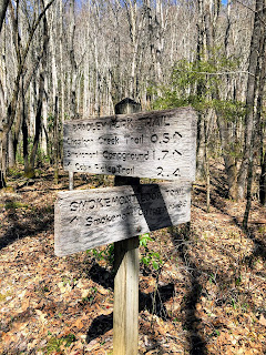
Phew... Was I ever glad to reach this sign! Dry Sluice Gap - Grassy Branch trail junction

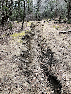
Typical deeply rutted trail along the upper end of Dry Sluice Gap.
I had intended to stay for a while here at the gap, to have lunch and sit and read for a while, but it was cold, the wind was fierce, and the sun was behind the clouds. So after about 15 minutes and a quick snack I packed up and headed back down.

The rest of the day was a bit of a downer. No sooner had I gotten back to my campsite when it started to rain. I jumped into my tent hoping it wouldn't last for long. Read for a bit and took a nap. The rain finally quit around 4 pm so I got out and enjoyed camp for a bit - reading by the river and exploring the campsite. But it was cold and windy and wet, so not awesome conditions for lounging around. Rain started up again at about 6 pm, so back to tent I went for the rest of the night. Got up the next morning to a covering of snow on the ground and super chilly conditions. Had a quick breakfast (coffee and oatmeal to warm up!) and took off.

Day 3: Cabin Flats backcountry campsite #49 up Bradley Fork to Hughes Ridge, out to the AT and back, down Hughes Ridge to Chasteen Creek, down to Bradley Fork and back to Smokemont Campground.
I was feeling pretty blah as I started the day. Too much time in the tent, along with wet and cold conditions... But as I started hiking, and the sun peeked over the ridge my spirits started to lift. I had a big climb right off the bat up Bradley Fork: 2100 feet elevation gain over 3.3 miles.

Ready to head up Bradley Fork trail (brr...)

Bradley Fork trail between Cabin Flats and Hughes Ridge
Bradley Fork trail continues to look like the old road that it is - wide and level, but pretty darned rocky. It rises steadily (relentlessly) as it climbs the side of Long Ridge on its way toward Hughes Ridge. It follows creeks for most of the way, which are always pleasant company. So many beautiful cascades and tiny waterfalls. A good distraction from the lung-busting climb. As I continued to climb it got colder and the snow got deeper. But the sun was out and I was working hard so I stayed warm. Coming into the gap where Bradley Fork meets Hughes Ridge was a big relief!

Woo-hoo! Happy to reach the top of Bradley Fork trail!
From here I needed to head left (north) on Hughes Ridge out toward the AT to Peck's Corner shelter to make a connection. I had stayed at Peck's Corner shelter on a backpack on the AT a few summers ago, but hadn't been any further down Hughes Ridge. The trail here is around 5000 feet in elevation and the fresh snow was about 3 inches deep. Hughes Ridge trail meanders up and down along the ridge - no steady up or down, just a bit of a roller coaster. The Peck's Corner shelter is about 2 miles north of the Bradley Fork junction. It looked like it had been well used the night before based on the foot traffic in the snow, but there was nobody there when I arrived about 11:30 am.

Peck's Corner Shelter (along with the ADA approved privy)

Hughes Ridge trail in the snow
I turned around from there and headed back south, following the ups and downs of Hughes Ridge on its way toward Chasteen Creek trail. As I descended along Hughes Ridge the snow got shallower, and ultimately turned to slush, and then gave way altogether. Near the end of Hughes Ridge trail you meet the Enloe Creek trail (which also forms part of the Benton MacKaye trail), and shortly thereafter reach the Chasteen Creek trail.

Snow turning to slush as I drop in elevation along Hughes Ridge trail

Hughes Ridge - Enloe Creek trail junction (white diamonds = Benton MacKaye trail)

Hughes Ridge - Chasteen Creek trail junction
Chasteen Creek trail drops from Hughes Ridge in the valley between Mine Ridge and Becks Bald, and follows Chasteen Creek and the many side creeks that flow into it. The upper part of Chasteen Creek drops quickly, and follows a ridge-side before reaching Chasteen Creek. There were nice views of the surrounding ridges through the leafless trees.

Upper section of Chasteen Creek trail

Views of the surrounding ridges - still covered in snow.

Early flowers of Trailing Arbutus (Epigea repens)
As the trail begins to follow Chasteen Creek though, it turns hellish... Like Bradley Fork trail, this is an old road, but the middle part of this trail is one long wide rock jumble. The little brown book warns that this section is often very muddy - luckily it was not yet. But the rocks! You have to pay very careful attention to every foot placement to avoid a turned ankle. I'll bet I added another mile to the distance just by wandering back and forth across the trail looking for a clear path. Needless to say, I didn't enjoy this section much. Glad I was coming down instead of going up! Somewhere in this section was campsite #48, but I missed it.

Rock-strewn Chasteen Creek trail
As you approach the bottom of Chasteen Creek trail it starts to level off and the rocks abate. There is a side trail leading to a horse area, and then shortly before the end is backcountry campsite #50. The campsite is a relatively small one with one fire ring and one set of bear cables, and sits right on creek and not far from the trail. Chasteen Creek trail ends at its junction with Bradley Fork trail, just below campsite #50.

Horse area on a side trail from Chasteen Creek

Backcountry campsite #50

Chasteen Creek - Bradley Fork trail junction
From this junction it's just 1.2 miles down Bradley Fork trail back to Smokemont Campground. The trail here is wide and smooth, and well-used by horses. It's an easy and mostly flat bit from here down to the campground. There is a trail junction with the Tow String horse trail, and also a junction with a connector to the Benton MacKaye trail that leads another mile down to the south end of Smokemont Campground. I will have to come back another time to do those 2 chunks of trail. Ultimately the Bradley Fork trail ends at the D-loop of the Smokemont Campground.


Bradley Fork trail near Smokemont Campground

Bradley Fork trail junction with Tow String horse trail, 0.2 miles above Smokemont Campground
The end! Bradley Fork trailhead in Smokemont Campground
While it had been in the upper 20s and snowy at 5000 feet on the Hughes Ridge trail, it was sunny and in the 60s when I got back to Smokemont! What a day of contrasts. I enjoyed this hike, but the long steep uphills on Dry Sluice Gap and then on Bradley Fork were challenging. Glad to have both of those behind me. Also glad to have made some connections with previous hikes, and marked off a few more trails in the long slow quest to finish all of the trails in the Smokies.

Hoping for some more multi-day backpacking trips this summer. I still have a lot of trails over in the Cataloochee section, and in the middle of the North Carolina side to do.

Til next time, happy hiking!