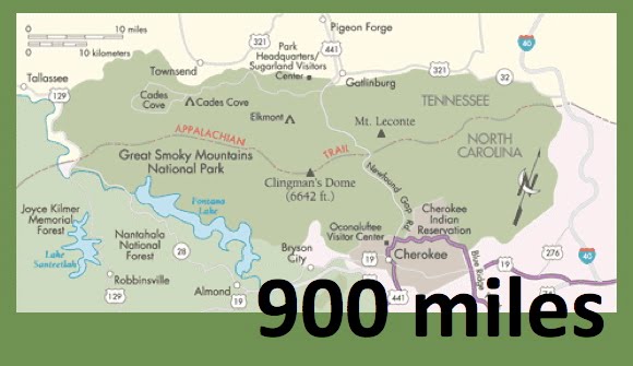
Here's the current park map with my progress traced in red. As you can see, the Tennessee side is all done (except for the Boulevard Trail), but there are big, blank areas on the North Carolina side. Gonna knock some of that out this summer!
Monday, May 18, 2020
Saturday, May 16, 2020
Gold Mine trail - Cooper Road trail - Beard Cane trail out and back
New Miles Completed: 3.6
Total Miles Hiked: 13.6 (+ a side trip of undetermined length...)
15 May 2020
Today I got to nearly finish up all the trails on the Tennessee side of the park by doing the Beard Cane trail. The only one left on this side is the Boulevard, and I'm saving that one for last.
In 2011 a tornado ripped through this end of the park and uprooted ginormous trees and played havoc with the trails. Beard Cane trail was in the tornado's direct path and as a result was closed for 2 years - I honestly didn't think it would ever open up again. But in 2013 it did, although campsite #11 appears closed for good, and there are lots of online warnings about how overgrown the trail can be if you go in the summer, the trail is open so today I decided to tackle it.
I parked on the road outside the park boundary near the Goldmine Trail to begin my journey.
It is that magical time of year in the Smokies when the wildflowers are out in full force and in particular, one of my favorites, Mountain Laurel. Normally the Annual Spring Wildflower Pilgrimage would have taken place in April, but that didn't happen because of the pandemic. So there's a virtual pilgrimage happening this week via iNaturalist and these were some of my contributions from today's hike:
I started on Gold Mine trail and on to Cooper Road trail, both of which I had done before. After the first 1.4 miles I arrived at Cane Gap where this is a manway out to the Lail Cemetery. I've been to this gap before and wondered where the "extra" trail led - one of my maps calls it the Buchanan Cemetery (but the "real" Buchanan Cemetery is on Cane Creek trail); the others call it the Lail Cemetery, and that's what it turned out to be. There is a single headstone in a clearing in the forest here memorializing the twin Lail sons. It's a sad story. The trail out from Cane Gap to the cemetery is probably 1 or 1.5 miles round trip with some big ups and downs.
From here I continued on the Cooper Road trail to its junction with the Hatcher Mountain and Beard Cane trails. I've been here before, several times. I enjoy the feeling of serendipity when I find myself revisiting spots in the Smokies. I turned left (north) on Beard Cane trail and this began the new section of trail for me. I had previously done the Ace Gap trail, and Beard Cane from Ace Gap down to CS#3 with our Scout Troop back in 2010. I just needed the 3.6 mile section of Beard Cane from the junction up to CS#3 to finish this trail.
Beard Cane trail starts on the ridge and follows a dry, piney, sunny route as it slowly descends toward Beard Cane creek. The mountain laurel were really getting going! In less than a mile the trail joins up with its namesake creek which it will follow all the way up to CS#3. For this first section you can really see the devastation wrought by the tornado. Many of the large canopy trees were felled and their trunks are piled willy nilly in the forest surrounding the trail. I can't even begin to imagine the amount of work it took to clear this trail to get it ready for hikers again! The trail itself is more of a wide, grassy, mucky, lumpy path through thick undergrowth on either side. I have always read NOT to attempt this trail in the summer when it becomes very overgrown and I can see why.
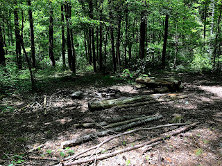
About a mile up the trail you come to the site of backcountry CS#11 which is permanently closed since the tornado. It looks like a jumble of Lincoln Logs - hard to believe there was ever a clearing big enough for a campsite!
Ultimately, the trail runs out of this open, sunny, mucky, overgrown stage and becomes a creek-side and creek-crossing path through pleasant forest. There are a LOT of creek crossings all along this trail, but the creek is rarely more than 6 inches deep and the crossings can all be rock-hopped. There is one beautiful section, maybe 25 yards long, in which the creek and trail are one and you must hop from rock to rock.
The trail continues in this way, following and crossing the creek on a nearly flat gradient all the way up to backcountry CS#3 (Hesse Creek campsite). This is a nice wide open campsite right at the confluence of Beard Cane Creek and Hesse Creek. There is a nice fire-ring area with several logs for sitting, one set of bear cables, and lots of flat spots for tents.
I stopped here for lunch, along with a big group from one of the local hiking clubs. After lunch they headed north toward Ace Gap, while I turned back south to retrace my steps back to the car. All in all it was a really lovely day, with amazing wildflowers and a fun trail. I'm glad I got to hike Beard Cane trail this time of year, and also glad to have the mental milestone of checking the last TN side trail off my list.
Hoping to get to spend some time over on the NC side this summer, maybe down in Bryson City to do a bunch of hikes out of there. Finishing my map seems simultaneously more and less reachable these days...
Til next time, happy hiking!
Total Miles Hiked: 13.6 (+ a side trip of undetermined length...)
15 May 2020
Today I got to nearly finish up all the trails on the Tennessee side of the park by doing the Beard Cane trail. The only one left on this side is the Boulevard, and I'm saving that one for last.
In 2011 a tornado ripped through this end of the park and uprooted ginormous trees and played havoc with the trails. Beard Cane trail was in the tornado's direct path and as a result was closed for 2 years - I honestly didn't think it would ever open up again. But in 2013 it did, although campsite #11 appears closed for good, and there are lots of online warnings about how overgrown the trail can be if you go in the summer, the trail is open so today I decided to tackle it.
I parked on the road outside the park boundary near the Goldmine Trail to begin my journey.
 |
| Goldmine Trail trailhead at the park boundary. |
 |
| Mountain Laurel (Kalmia latifolia) in flower |
I started on Gold Mine trail and on to Cooper Road trail, both of which I had done before. After the first 1.4 miles I arrived at Cane Gap where this is a manway out to the Lail Cemetery. I've been to this gap before and wondered where the "extra" trail led - one of my maps calls it the Buchanan Cemetery (but the "real" Buchanan Cemetery is on Cane Creek trail); the others call it the Lail Cemetery, and that's what it turned out to be. There is a single headstone in a clearing in the forest here memorializing the twin Lail sons. It's a sad story. The trail out from Cane Gap to the cemetery is probably 1 or 1.5 miles round trip with some big ups and downs.
 |
| Headstone for the Lail twins, Ralph & Raymond |
Beard Cane trail starts on the ridge and follows a dry, piney, sunny route as it slowly descends toward Beard Cane creek. The mountain laurel were really getting going! In less than a mile the trail joins up with its namesake creek which it will follow all the way up to CS#3. For this first section you can really see the devastation wrought by the tornado. Many of the large canopy trees were felled and their trunks are piled willy nilly in the forest surrounding the trail. I can't even begin to imagine the amount of work it took to clear this trail to get it ready for hikers again! The trail itself is more of a wide, grassy, mucky, lumpy path through thick undergrowth on either side. I have always read NOT to attempt this trail in the summer when it becomes very overgrown and I can see why.
About a mile up the trail you come to the site of backcountry CS#11 which is permanently closed since the tornado. It looks like a jumble of Lincoln Logs - hard to believe there was ever a clearing big enough for a campsite!
 |
| The site of backcountry campsite #11 |
 |
| Beard Cane trail and creek are the same! |
 |
| CS#3 trail marker |
 |
| CS#3 fire ring & sitting area |
Hoping to get to spend some time over on the NC side this summer, maybe down in Bryson City to do a bunch of hikes out of there. Finishing my map seems simultaneously more and less reachable these days...
Til next time, happy hiking!
Subscribe to:
Posts (Atom)


