Total Miles Hiked: 32.6
3 day / 2 night backpack, 20-22 March 2019
It's been a long time since I've added any new trail miles to the quest. Took advantage of Spring Break to get in a backpack out of Smokemont campground to do a few new trails and make some connections with prior hikes.
Day 1: Smokemont Campground to Cabin Flats backcountry campsite #49.
Arrived at Smokemont Campground around 1 pm. Had a hard time figuring out where to park near the Smokemont Loop trailhead - there don't seem to be any designated parking spaces for hikers. Ended up parking in the extra spaces for the campground loop A. My car was still there when I got back, so I guess it was ok.
Smokemont Loop trail starts out on a bridge over the Oconaluftee River, and then follows an old road for a bit. Pretty quickly it leaves the old road, and turns off to the right and uphill.
 |
| At the Smokemont Loop trailhead |
 |
| Beginning of the Smokemont Loop trail. Sign @ junction where the trail rises into the woods. |
 |
| Bradley Fork bridge |
 |
| Early spring wildflower: Liverleaf (Hepatica) |
 |
| Smokemont Loop - Bradley Fork trail junction |
From there I headed up the Bradley Fork trail toward Cabin Flats. Bradley Fork trail is an old road that follows the creek gently up the valley. Bradley Fork is a beautiful creek, and it was running full and fast. Lots of nice little waterfalls running into it from the sides.
 |
| Bradley Fork trail - a nice wide old roadbed |
 |
| Bradley Fork |
 |
| Cascade running into the Bradley Fork |
 |
| Cool old bridge on Cabin Flats trail |
 |
| Cabin Flats - Dry Sluice Gap trail junction |
 |
| Cabin Flats campsite #49 |
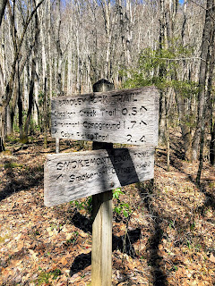
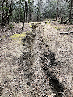
On a previous day hike I had done the AT - Sweat Heifer - Grassy Branch - Dry Sluice Gap - AT loop, so I had been to the Grassy Branch - Dry Sluice Gap trail junction before, but I had not done the section of Dry Sluice Gap between there and Cabin Flats. So that was my goal for the day. The trail elevation profile for this chunk looks daunting - 3200 feet of elevation gain over 2.9 miles. It was a steady UP for sure. The bottom part wends its way up along creeks and across ridges through mostly open woods. The creeks were beautiful and noisy and the trail was mostly good. Then the trail starts to rise even more steeply up the side of a ridge. You reach the lower limit of Red Spruce at about 4500 feet elevation. The trail starts to get deeply rutted, rocky and rooty. When I finally saw the trail sign at the junction I was very happy to finally be there!
 |
| Leaving Cabin Flats on the Dry Sluice Gap trail |
 |
| Red Spruce (Picea rubens) starts to appear at about 4500-5000 feet elevation |
 |
| Phew... Was I ever glad to reach this sign! Dry Sluice Gap - Grassy Branch trail junction |
 |
| Typical deeply rutted trail along the upper end of Dry Sluice Gap. |
The rest of the day was a bit of a downer. No sooner had I gotten back to my campsite when it started to rain. I jumped into my tent hoping it wouldn't last for long. Read for a bit and took a nap. The rain finally quit around 4 pm so I got out and enjoyed camp for a bit - reading by the river and exploring the campsite. But it was cold and windy and wet, so not awesome conditions for lounging around. Rain started up again at about 6 pm, so back to tent I went for the rest of the night. Got up the next morning to a covering of snow on the ground and super chilly conditions. Had a quick breakfast (coffee and oatmeal to warm up!) and took off.
Day 3: Cabin Flats backcountry campsite #49 up Bradley Fork to Hughes Ridge, out to the AT and back, down Hughes Ridge to Chasteen Creek, down to Bradley Fork and back to Smokemont Campground.
I was feeling pretty blah as I started the day. Too much time in the tent, along with wet and cold conditions... But as I started hiking, and the sun peeked over the ridge my spirits started to lift. I had a big climb right off the bat up Bradley Fork: 2100 feet elevation gain over 3.3 miles.
Bradley Fork trail continues to look like the old road that it is - wide and level, but pretty darned rocky. It rises steadily (relentlessly) as it climbs the side of Long Ridge on its way toward Hughes Ridge. It follows creeks for most of the way, which are always pleasant company. So many beautiful cascades and tiny waterfalls. A good distraction from the lung-busting climb. As I continued to climb it got colder and the snow got deeper. But the sun was out and I was working hard so I stayed warm. Coming into the gap where Bradley Fork meets Hughes Ridge was a big relief!
From here I needed to head left (north) on Hughes Ridge out toward the AT to Peck's Corner shelter to make a connection. I had stayed at Peck's Corner shelter on a backpack on the AT a few summers ago, but hadn't been any further down Hughes Ridge. The trail here is around 5000 feet in elevation and the fresh snow was about 3 inches deep. Hughes Ridge trail meanders up and down along the ridge - no steady up or down, just a bit of a roller coaster. The Peck's Corner shelter is about 2 miles north of the Bradley Fork junction. It looked like it had been well used the night before based on the foot traffic in the snow, but there was nobody there when I arrived about 11:30 am.
I turned around from there and headed back south, following the ups and downs of Hughes Ridge on its way toward Chasteen Creek trail. As I descended along Hughes Ridge the snow got shallower, and ultimately turned to slush, and then gave way altogether. Near the end of Hughes Ridge trail you meet the Enloe Creek trail (which also forms part of the Benton MacKaye trail), and shortly thereafter reach the Chasteen Creek trail.
Chasteen Creek trail drops from Hughes Ridge in the valley between Mine Ridge and Becks Bald, and follows Chasteen Creek and the many side creeks that flow into it. The upper part of Chasteen Creek drops quickly, and follows a ridge-side before reaching Chasteen Creek. There were nice views of the surrounding ridges through the leafless trees.
As the trail begins to follow Chasteen Creek though, it turns hellish... Like Bradley Fork trail, this is an old road, but the middle part of this trail is one long wide rock jumble. The little brown book warns that this section is often very muddy - luckily it was not yet. But the rocks! You have to pay very careful attention to every foot placement to avoid a turned ankle. I'll bet I added another mile to the distance just by wandering back and forth across the trail looking for a clear path. Needless to say, I didn't enjoy this section much. Glad I was coming down instead of going up! Somewhere in this section was campsite #48, but I missed it.
As you approach the bottom of Chasteen Creek trail it starts to level off and the rocks abate. There is a side trail leading to a horse area, and then shortly before the end is backcountry campsite #50. The campsite is a relatively small one with one fire ring and one set of bear cables, and sits right on creek and not far from the trail. Chasteen Creek trail ends at its junction with Bradley Fork trail, just below campsite #50.
From this junction it's just 1.2 miles down Bradley Fork trail back to Smokemont Campground. The trail here is wide and smooth, and well-used by horses. It's an easy and mostly flat bit from here down to the campground. There is a trail junction with the Tow String horse trail, and also a junction with a connector to the Benton MacKaye trail that leads another mile down to the south end of Smokemont Campground. I will have to come back another time to do those 2 chunks of trail. Ultimately the Bradley Fork trail ends at the D-loop of the Smokemont Campground.
While it had been in the upper 20s and snowy at 5000 feet on the Hughes Ridge trail, it was sunny and in the 60s when I got back to Smokemont! What a day of contrasts. I enjoyed this hike, but the long steep uphills on Dry Sluice Gap and then on Bradley Fork were challenging. Glad to have both of those behind me. Also glad to have made some connections with previous hikes, and marked off a few more trails in the long slow quest to finish all of the trails in the Smokies.
Hoping for some more multi-day backpacking trips this summer. I still have a lot of trails over in the Cataloochee section, and in the middle of the North Carolina side to do.
Til next time, happy hiking!
I was feeling pretty blah as I started the day. Too much time in the tent, along with wet and cold conditions... But as I started hiking, and the sun peeked over the ridge my spirits started to lift. I had a big climb right off the bat up Bradley Fork: 2100 feet elevation gain over 3.3 miles.
 |
| Ready to head up Bradley Fork trail (brr...) |
 |
| Bradley Fork trail between Cabin Flats and Hughes Ridge |
 |
| Woo-hoo! Happy to reach the top of Bradley Fork trail! |
 |
| Peck's Corner Shelter (along with the ADA approved privy) |
 |
| Hughes Ridge trail in the snow |
 |
| Snow turning to slush as I drop in elevation along Hughes Ridge trail |
 |
| Hughes Ridge - Enloe Creek trail junction (white diamonds = Benton MacKaye trail) |
 |
| Hughes Ridge - Chasteen Creek trail junction |
 |
| Upper section of Chasteen Creek trail |
 |
| Views of the surrounding ridges - still covered in snow. |
 |
| Early flowers of Trailing Arbutus (Epigea repens) |
 |
| Rock-strewn Chasteen Creek trail |
 |
| Horse area on a side trail from Chasteen Creek |
 |
| Backcountry campsite #50 |
 |
| Chasteen Creek - Bradley Fork trail junction |
 |
| Bradley Fork trail near Smokemont Campground |
 |
| Bradley Fork trail junction with Tow String horse trail, 0.2 miles above Smokemont Campground |
 |
| The end! Bradley Fork trailhead in Smokemont Campground |
Hoping for some more multi-day backpacking trips this summer. I still have a lot of trails over in the Cataloochee section, and in the middle of the North Carolina side to do.
Til next time, happy hiking!


No comments:
Post a Comment