New Miles Hiked: 13.9
Total Miles Hiked: 24.9
1-2 Oct. 2021
 |
| Day 1 in red, camped at Newton Bald (#52 in blue), Day 2 in green. |
Needed a few more trails to wrap up all of the trails in the Deep Creek area. Day 1 was a nice meander along Deep Creek, then UP Martins Gap, and UP Sunkota Ridge to Newton Bald trail and backcountry campsite #52 for the night. Then day 2 was down Thomas Divide to Deeplow Gap, then UP Indian Creek Motor trail, then down Thomas Divide, and emptying out via Stone Pile Gap, Indian Creek & Deep Creek trails.
 |
| Trailhead selfie at Deep Creek campground |
Parked at Deep Creek campground. I really like Bryson City and the Deep Creek area. Seems like lots of locals come here to picnic, enjoy short hikes or trail run. The small hiker parking lot was already full when I arrived around noon, so I circled back and parked in the nearby picnic area. Got everything out and ready to hit the trail.
 |
| Fly fisherman enjoying Deep Creek |
Deep Creek is an idyllic waterway. Wide and rocky with smooth flowy areas, and small cascades and rapids. During the summer it teems with tubers. The fly fishermen have to compete for space with other recreational users. It's just a beautiful Smoky mountain creek.
 |
| Deep Creek trail |
The Deep Creek trail closely parallels Deep Creek for the first couple of miles, and the path is wide and sandy/rocky. Fall flowers were on full display.
 |
Fall flowers
|
After passing the Indian Creek trail at about 0.7 miles, the Deep Creek Horse trail at about 0.8 miles, and then the Loop trail at about 1.8 miles, the Deep Creek trail begins to rise above the creek itself. There's about 500' of elevation gain from the trailhead to backcountry campsite #57 and Martins Gap trail.
 |
| Confusing trail junction: Deep Creek trail heads right and uphill. |
At one point the trail seems to split into three separate trails: two of which continue to parallel the creek (fisherman trails, or bike trails maybe?), and the third, furthest to the right with the trail sign, starts to climb up to the ridge above the creek. There's a lot of good trail work in this section: boardwalks, water bars, some nice rock work at creek crossings. Kudos to the trail maintainers who keep these trails in good shape!
 |
| Small cascade & creek that cross Deep Creek trail: nice stonework to provide a walk-way and a path for the creek |
 |
| Fall foliage |
There are several relatively closely-spaced campsites on this section of Deep Creek: #60 (Bumgardner Branch), #59 (McCracken Branch), #58 (Nicks Nest Branch), and #57 (Bryson Place). There are even more as you continue up Deep Creek trail.
 |
| Backcountry campsite #60 trail marker |
 |
| Backcountry campsite #60 |
I first passed #60, and it was well-occupied. Several tents, tarps, and hammocks set up and folks enjoying the day. I didn't want to intrude so I didn't stop to investigate too much, but it looked to be a nice, wide-open campsite with plenty of flat spots for tents, and the creek nearby for water.
 |
| Deep Creek trail |
The trail continued to rise in elevation along this section, with some steps and water bars and pleasant forest trail.
 |
| Deep Creek trail is lined with New York fern in places |
 |
| Bridge Creek cascades into Deep Creek |
 |
| The long view of Deep Creek |
 |
Backcountry campsite #59 trail marker
|
I stopped in to campsite #59 to take a break, and found some other folks there who were also taking a trail break. They included a couple of 900-hundred-milers, and their companion who is working on it. We enjoyed swapping info and resting together for a bit before I continued to head north and up. Campsite #59 seemed pretty small, although the capacity is listed as 10, but had good flat tent spots and good creek access.
 |
| Backcountry campsite #58 |
Just a little further up the trail I also briefly stopped in at campsite #58. The capacity for this site is listed as 6, and it also seemed small, but with some good flat tent spots and good access to water.
 |
| Martins Gap - Deep Creek trail junction |
 |
| Backcountry campsite #57 |
At campsite #57 the Deep Creek trail reaches its junction with the Martins Gap trail. This is where I would turn right (east) and UP, and to new trail miles. Campsite #57 (Bryson Place) is famous for being Horace Kephart's last permanent camp in the Smokies. Kephart was a great advocate for the national park and author of "Our Southern Highlanders" - an exceptional description of the area of the GSMNP before it was a park. Highly recommended to read!
My route was up Martins Gap trail to Martins Gap where I would pick up the Sunkota Ridge trail heading north (and more up). This section of Martins Gap trail (from Deep Creek to Martins Gap) is pretty straight up. You gain about 1000' of elevation over 1.5 miles. The trail climbs through and along the edge of the ridges up to the Sunkota Ridge at Martins Gap, so not a lot of views but a good climb through the forest. There were several big blow-downs along my whole route this time, including this big one on Martins Gap trail. It was passable for sure, but required some scrambling over and under the brush.
 |
| Big blow-down on Martins Gap trail |
 |
| up, Up, UP on Martins Gap trail |
 |
| More fall botanicals |
 |
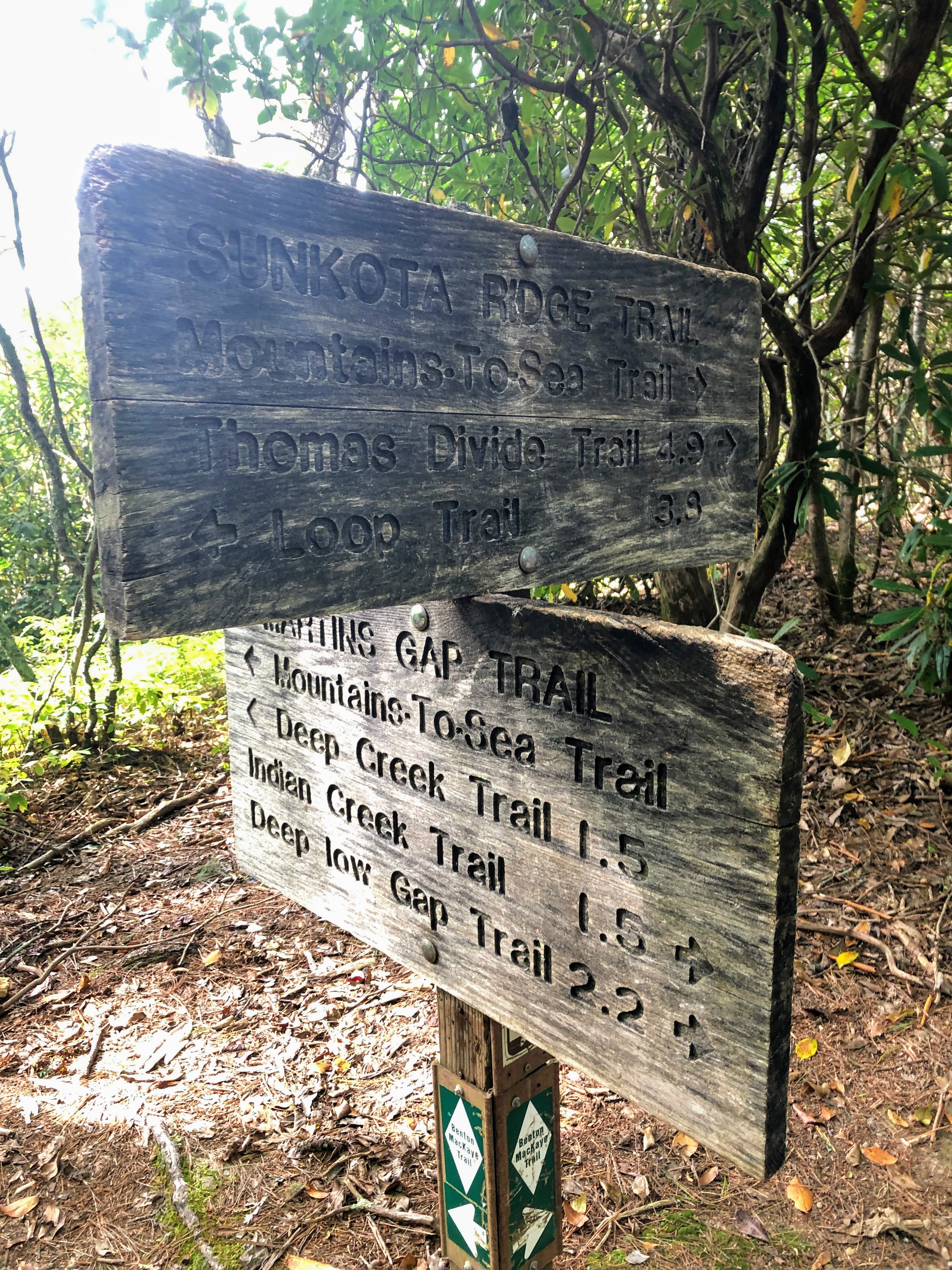
| Martins Gap - Sunkota Ridge trail junction at Martins Gap |
I stopped here at Martins Gap for a break, and remembered my previous efforts in the Deep Creek area when I couldn't make the ups and downs... It felt good to be back in the area and making good progress! From here my route turned north on the Sunkota Ridge trail, up toward the Thomas Divide trail and Newton Bald. I was admittedly nervous. This section of Sunkota Ridge is almost 5 miles long, and I was afraid it was going to be straight up for 5 miles... Luckily, that was not the case.
 |
| Sunkota Ridge trail |
 |
| Fall beginning to show in the Sourwood and Blueberry leaves! |
I was really pleasantly surprised with this section of the Sunkota Ridge trail. While it gains about 1400' in elevation from Martins Gap to the Thomas Divide trail, it (mostly) does so gently. The first few miles were really pleasant, walking through the woods with ferns and grasses along the trail, with some ups and then some flat sections, and so on. You could see fall beginning in the colors of the leaves of the Sourwoods, the Blueberries, the Chestnuts, and the Sassafras!
The last mile or so before you reach Thomas Divide trail definitely gets steeper, but I was so relieved that the whole thing wasn't steep that I didn't even really notice.
 |
| up, Up, UP the last bit of Sunkota Ridge! |
 |
| Phew... the Sunkota Ridge - Thomas Divide trail junction, just north of Newton Bald |
The junction with Thomas Divide trail took me back a couple of years. In 2019 I did Kanati Fork and the upper chunk of Thomas Divide. I had stopped at this trail junction, and looking at the map, tried to imagine when I would be back. And here I was. One of my favorite parts about the journey - all of the connections.
 |
| Thomas Divide trail from Sunkota Ridge to Newton Bald |
 |
| Trail junction: Thomas Divide and Newton Bald trails |
I hiked the 0.4 miles from the Thomas Divide-Sunkota Ridge trail junction down to the Newton Bald trail, and then turned left (east) on Newton Bald trail for just 0.2 miles to backcountry campsite #52 (Newton Bald). This was my destination for the night. Last time I was here was January, 2021 and the snow was deep enough that I couldn't find the fire ring! Campsite #52 is nice with tent areas down in the gap (near the bear cables and the trail to the water source) and an upper area on a little knoll above the rest of the campsite. Set up the tent, had dinner, did a little reading, and then headed off to bed around 9:30 pm. I was beat! Also, the water source for campsite #52 is good, but it's a fair bit DOWN and the back UP from the campsite itself. Not a trip you want to make multiple times if you don't have to... Met some other really nice folks camping there.
Good night!
---
Got up and ate breakfast and packed up Saturday morning to get ready to head back down. I am still experimenting with a variety of trail foods, and must say the breakfast meal I had this morning was less than satisfying... Good thing I had some pop-tarts bites to go along with it!
The campsite and trail were socked in with early morning fog which was beautiful!!!
 |
| Fog encasing CS#52 in the early morning |
 |
| Morning selfie - getting ready for new miles on Thomas Divide |
 |
| Walking through the early morning fog on Thomas Divide |
More new trail miles today. 0.2 miles back to the trail junction between Newton Bald and Thomas Divide trails and then down Thomas Divide for 3.1 miles. The trail drops about 1300' in elevation from here to Deeplow Gap. It's a pleasant, mostly ridge-top / ridge-side trail through open woods, with some flattish sections near to the top, and then a pretty continuous descent down into the gap for the last couple of miles.
 |
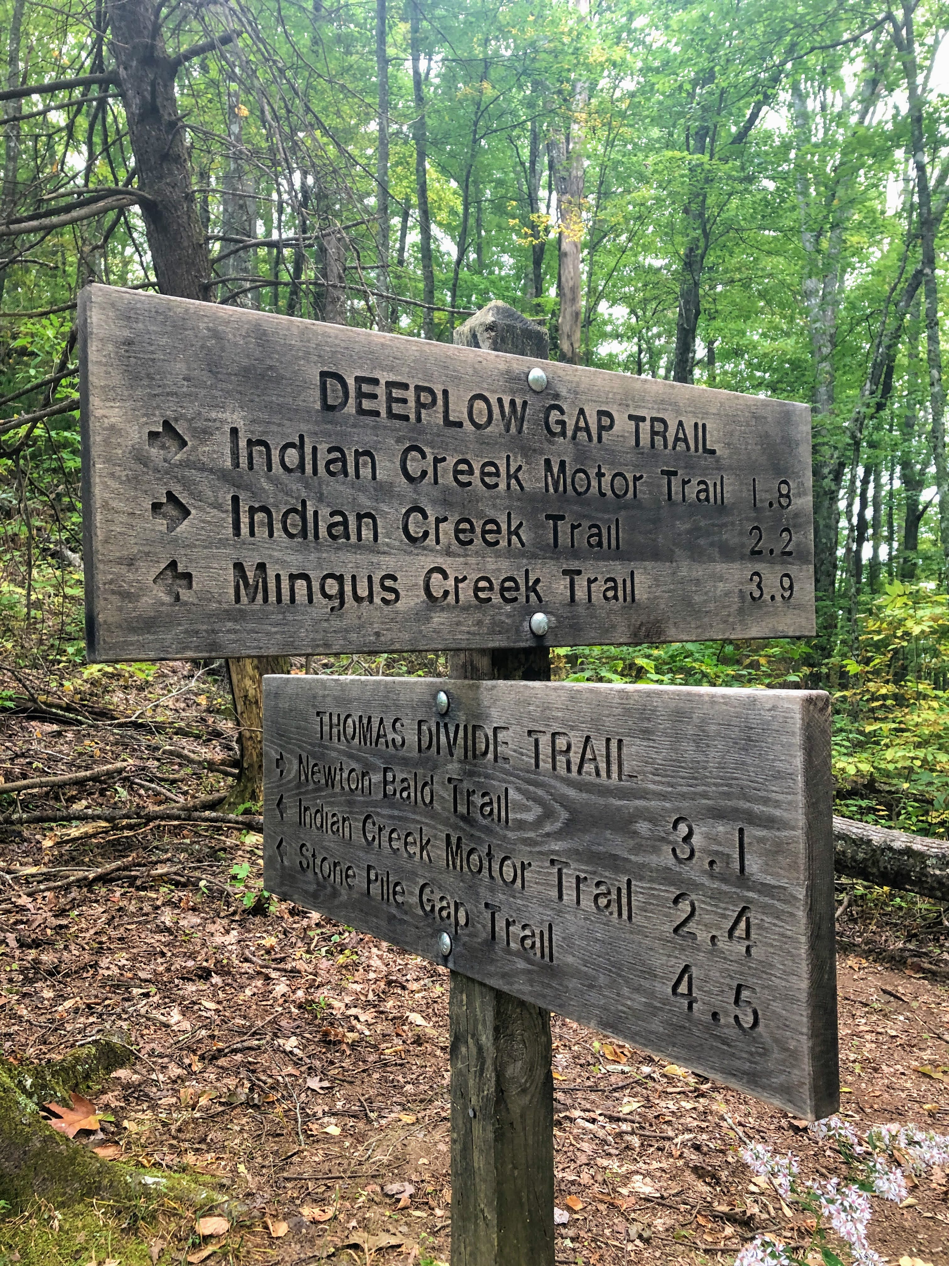
| Thomas Divide - Deeplow Gap trail junction |
Here at Deeplow Gap I turned right (west) onto Deeplow Gap Trail which drops down the ridge into the valley formed by Georges Branch, a creek that the trail follows for much of the lower section. It drops another 1300' in elevation from Deeplow Gap to its end at the Indian Creek trail junction.
 |
| Down Deeplow Gap trail |
 |
| More fall wildflowers |
 |
| Deeplow Gap trail |
 |
| Backcountry campsite #51 Georges Branch |
 |
Backcountry campsite #51 Georges Branch
|
Not far above the junction of Deeplow Gap and Indian Creek Motor trail lies backcountry campsite #51 (Georges Branch), which must be sort of new. It is not shown on my 2010 Nat Geo map, but it is on the 2011 version of the GSMNP $1 map (same goes for campsite #46 Estes Branch which is not far away on Indian Creek trail). This campsite is pretty open, doesn't look to have very many really flat spots for tents, but does have a campfire ring and set of bear cables.I hung my pack here so I could make the hike down 0.4 miles to the end of Deeplow Gap trail and then back up without having to carry my pack the whole way.
 |
| Deeplow Gap - Indian Creek Motor Trail junction |
Just a tenth of a mile below CS#51 you reach the trail junction with Indian Creek Motor trail which is where I would be heading next, but had to make the quick run down to Indian Creek trail and back first. This section (between Indian Creek Motor Trail and Indian Creek Trail) is clearly part of an old road system - wide and rocky, and with a nice bridge over Georges Branch.
 |
| Bottom section of Deeplow Gap trail |
 |
| Deeplow Gap - Indian Creek trail junction |
I reached the end of Deeplow Gap trail at Indian Creek trail, and then turned back up to retrieve my pack back at CS#51 and then turn down south on Indian Creek Motor trail. As its name implies, Indian Creek Motor trail is an old road. From the Deeplow Gap trail to Thomas Divide trail is 1.8 miles and gains about 900' of elevation. The ascent was pretty steady - what you might expect for a road, and not especially scenic. The trail hugs the contour of the ridge, rising steadily.
 |
| Indian Creek Motor Trail rising from the Deeplow Gap trail. |
 |
| Up, up, up - steady ascent on Indian Creek Motor Trail. |
 |
| Thomas Divide - Indian Creek Motor Trail junction |
Finally (quite happily!) reached the Thomas Divide trail again at the top of Indian Creek Motor trail. This ends my new miles for this trip. From here I continued back down Thomas Divide to Stone Pile Gap trail, then to Indian Creek trail (with a stop at Indian Creek Falls), then back to Deep Creek trail and back to my car.
Really nice to get this section of trails wrapped up, with beautiful fall weather, and really nice terrain to walk. I love this section of the park. Deep Creek is a nice campground and the trails in the area are lovely. Also really like Bryson City - it's a quaint small town with some fun shops and restaurants and a very outdoorsy vibe.
Slowly chipping away at the last few trails to complete. Maybe I'll get to squeeze in another trip this fall.
Til next time, happy hiking!


No comments:
Post a Comment