Sunday, July 17, 2016

Appalachian Trail - Sweat Heifer - Grassy Branch - Dry Sluice Gap - Appalachian Trail loop hike

New miles completed: 7.5
Total miles hiked: 14.6
13 July 2016

A few weeks ago we did the Kephart Prong trail as an out-and-back.  So this week I decided to go ahead and knock out the other trails around this area.  I had previously done the hike along the Appalachian Trail (AT) from Newfound Gap north a few times, but on this trip I made a loop out of it.  Started out on the AT from Newfound Gap, then down the Sweat Heifer trail to Kephart Shelter, then up the Grassy Branch trail to Dry Sluice Gap trail, then back to the AT for the return to Newfound Gap.  Along the way I stopped by Charlie's Bunion, Icewater Springs Shelter, and for the first time took the hike out to the Jumpoff.

Got to Newfound Gap and the trailhead around 8:30 am, and there were already lots of folks there.  Upon arrival I discovered that I had left my boots back in my dining room, which left me doing a 14+ mile hike in my trail runners.  That was an experiment I had intended to try, but not on this particular day.  Oh well!

AT trailhead at Newfound Gap

Left my boots at home...
The 1.7 mile section of the AT from Newfound Gap to the junction with Sweat Heifer trail was already fairly busy with day hikers headed out towards Charlie's Bunion.  The trail here is on or skirts the central ridge of the Smokies and you can tell - it's like you're walking on the bones of the mountains.  The trail is pretty rocky, with big chunks of exposed boulders, and it rises pretty steadily, gaining about 800 feet in elevation.  There are occasional views off to the side.

I reached the junction of the AT and Sweat Heifer trail, and turned downhill.  Here I met Tom - a fellow hiker and 900-miler club aspirant who was doing the same loop as me.  We chatted briefly and then met each other off and on through the rest of the day which was pretty cool.

AT - Sweat Heifer trail junction

Beginning of the Sweat Heifer trail - very overgrown!
Sweat Heifer trail loses about 2200 feet of elevation over 3.7 miles from the AT down to its end at the Kephart Shelter.  The top half is a pretty steady descent, there's a very pleasant section in the middle that levels out a bit, and then it drops off again heading down and into the the shelter.  It doesn't seem to be a terribly well-traveled trail. The top bit coming down from the AT was VERY overgrown, with grass up to my knees growing over the trail - at times it was tough to see where the trail was!  The walk was through very pleasant forest, there are constructed steps in many of the steep places, and there were lots of wildflowers to look at including crimson bee-balm, white bergamot, and monkshood.

Sweat Heifer cascades

Sweat Heifer creek

Once I reached the Kephart Shelter I met up with Tom again.  We both stopped here to eat and rest a bit.  We chatted about trails, and gear, boy scouts, and our experiences in the Smokies.  It was really very nice!  We also both knew that the next part of the hike was going to be the most grueling part of the day.  The ascent up Grassy Branch trail.

Kephart Shelter

Sweat Heifer - Grassy Branch trail junction @ Kephart Shelter
Grassy Branch trail gains about 1800 feet over 2.5 miles from Kephart Shelter to its junction with Dry Sluice Gap trail.  And it is relentless...  There are lots of switchbacks and it just goes up and up and up.  The day was pretty warm and very humid - I was soaked with sweat pretty much right away.  The surrounding woods here are pleasant, but nothing exceptional.  No waterfalls, or great views.  Towards the top the trail becomes deeply rutted and eroded.  I can tell you I was happy to reach the junction with Dry Sluice Gap trail!

Grassy Branch - Dry Sluice Gap trail junction
The section of Dry Sluice Gap trail between Grassy Branch and the AT is quite nice.  It rises a bit, then levels out, before descending gently to the AT, but is never steep.  To whoever does trail maintenance on this trail - thank you!  The grass at the trail edge was so neatly cut it looked as if someone had recently been through with a weedeater!  This little 1.3 mile chunk passed quickly and pleasantly, and brought me back to the Appalachian Trail.

The very well-kept Dry Sluice Gap trail

Dry Sluice Gap - Appalachian Trail junction
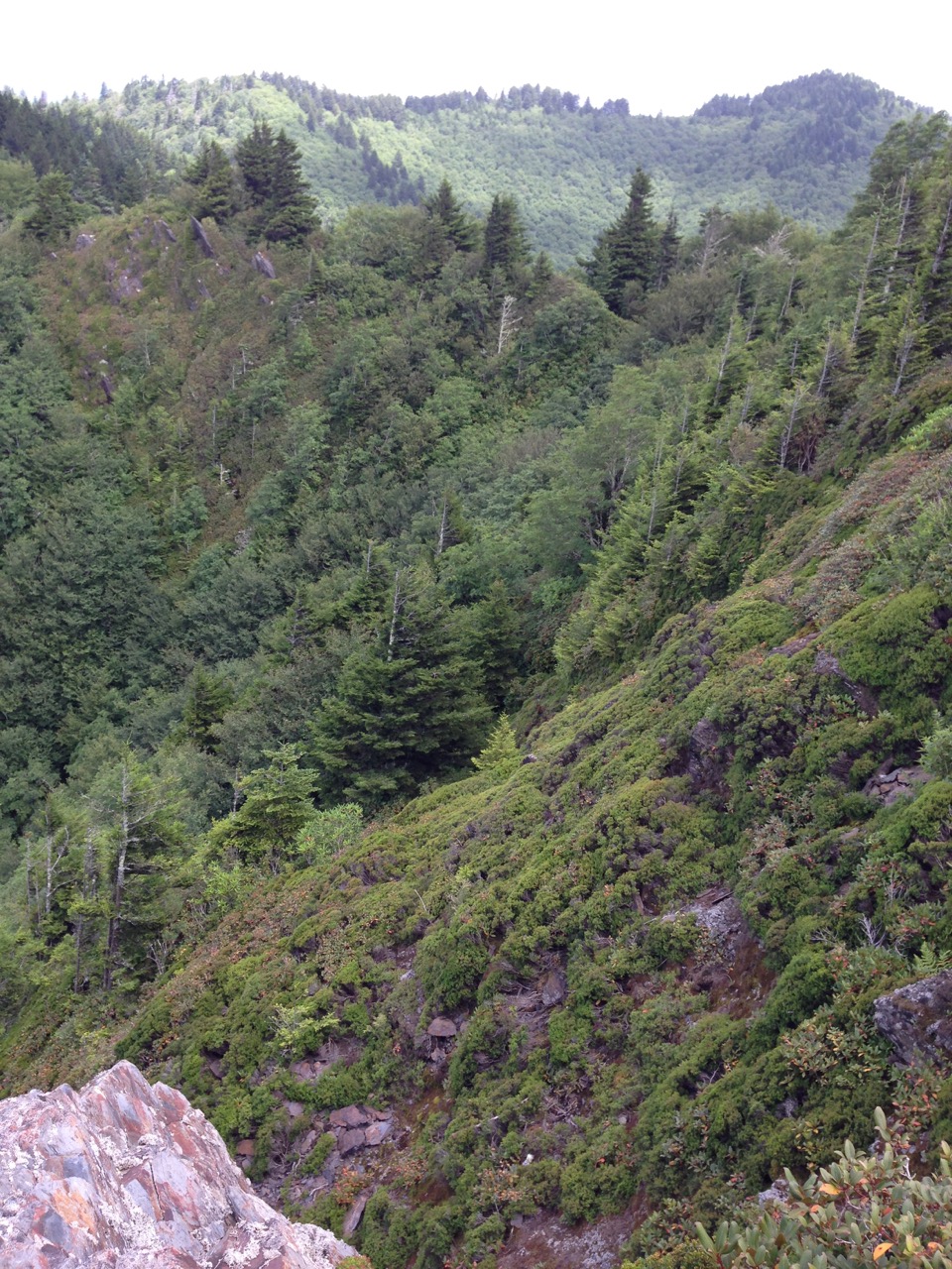
From here I turned back southwest on the AT toward Newfound Gap.  Along the way are outstanding views to either side of the trail.

View from the AT
Just a little bit down the trail brought me to the side trail to Charlie's Bunion - a really great destination on the AT.  A big rock outcrop sticks out of the side of the mountain and affords really outstanding views of the surrounding mountain ranges, as well as impressive views of the steepness of the mountains in the immediate vicinity.

Selfie at Charlie's Bunion

View of the steep mountainsides adjacent to Charlie's Bunion
From Charlie's Bunion the trail climbs steadily as you head southwest, passing Icewater Spring, and the nearby shelter.  A quarter of a mile or so past Icewater Spring Shelter you reach the junction with the Boulevard trail which leads to Mt. LeConte.  It also shortly leads to a side trail to the Jump Off - a spot at the top of a very sheer cliff that provides really amazing views.  I'd never been out to the Jump Off, so I decided to give it a go.  

Appalachian Trail - Boulevard Trail junction

Side trail to the Jump Off

View from the Jump Off
While a rough trail with some tall steps and steep ups and downs, it was well-worth the trip.  The Jump Off is just a small open spot at the top of a tall and sheer cliff.  For people like me with a healthy respect for heights it can be a bit unnerving - the only thing between you and a several hundred feet sheer drop is a couple of bushes...  But the views are outstanding, and I'm really glad I took the time to visit.

From here the AT heads mostly downhill back to Newfound Gap in about 2.7 miles.  Even though it was nearly 4 pm by this time I still ran into a lot of folks who were heading out from Newfound Gap!  Summer time in the GSMNP.

I happily made it back to Newfound Gap and my car after my 14+ miles day, including a lot of up and down.  My feet felt surprisingly good after the day in my trail runners.  They certainly were not as tired as they normally are in my big boots, but I also felt the rocks more and was more careful about where I stepped to avoid turning my ankles.  Undoubtedly there are pros and cons to both approaches, but I think I might try a real pair of trail shoes next.

All in all, another great day on the trails in the Smokies!  Amazing views from the AT, and some very nice hiking through beautiful high-elevation forest.  Looking forward to knocking off a few more trails this summer.

Til next time, happy hiking!

Thursday, June 30, 2016

Kephart Prong trail

New miles completed: 2.0
Total miles hiked: 4.0
29 June 2016

I've reached the point in my quest when I have done nearly all of the trails on the Tennessee side of the park (where I live), so new trails are going to have to be added on the North Carolina side, which means more driving and better planning.  OR, somedays, like this day, we will take a nice drive over the mountains just to do a little 2 mile section of trail...  It was a beautiful summer day spent with good friends exploring a little more of our big back yard.

The Kephart Prong trailhead is on Newfound Gap Road, about 8.8 miles south of Newfound Gap or 5.0 miles north of Smokemont Campground.  The trail is only 2 miles long, and gains about 800 feet in elevation as it follows the Kephart Prong (stream) along an old jeep road turned trail.

Our hiking crew at the trailhead

The trail begins at at large footbridge over the Oconaluftee River right where the Kephart Prong flows into the Oconaluftee.  Pretty much the entire length of the trail is a nice walk through the woods while following the Kephart Prong, banks lined with Rosebay Rhododendron.  This time of year the Rhododendron and Scarlet Bee Balm are in flower - they put on a lovely show!  Also found a nice patch of Pipsissewa in flower.

Rosebay Rhododendron
Pipsissewa, aka Spotted Wintergreen
Scarlet Bee Balm

Kephart Prong
Almost immediately up the trail you start to see signs of prior habitation.  There are many side trails that now lead off into the woods and just peter out...  Some even have old stonework entrances.

Side trail off of the Kephart Prong with stone walls flanking the path.
Shortly thereafter you reach the site of an old CCC camp.  The little brown book and the History Hikes book both give good info about this site.  The CCC did a huge amount of work in the Smokies in the 1930s building trails, bridges and buildings.  This site has some of the most obvious leftovers I've seen in former CCC campsites in the park.

River stone sign board

River stone water fountain

Chimney
From here on up the trail follows a familiar pattern of hugging one side of Kephart Prong for a while, then crossing over to the other side for a while.  Beyond the first bridge at the trailhead, there are four additional footbridges that cross Kephart Prong.

Footbridge #1

Footbridge #2

Footbridge #3

Footbridge #4
At all of the stream crossings you have a choice - you can either take one side trail and ford the creek, or you can take a different side trail and cross the footbridge.  There are even signs to point you in the right direction!

"Foot Log" - sign pointing to the bridge crossing
The trail is very rocky.  It's fairly wide in the first mile (the old jeep road), but then narrows further on.

Ultimately, 2 miles from the trailhead, you reach the end of the Kephart Prong trail where it reaches a junction with both the Sweat Heifer and Grassy Branch trails, and the Kephart backcountry shelter.

Trail junction with Sweat Heifer and Grassy Branch trails.

Kephart backcountry shelter 
We stopped here to snack and drink and play in the water just around the corner from the shelter before heading back down the trail.  It was a beautiful summer day and a very pleasant hike.  Kephart Prong is a very pretty stream, and the creek crossings provide plenty of opportunities to play in the water if you wish!

Hope you all are having a great summer on the trails.
Til next time, happy hiking!

Tuesday, January 19, 2016

Backpacking loop: Middle Prong - Greenbrier Ridge - AT - Miry Ridge - Panther Creek - Middle Prong

New miles completed: 6.7
Total miles hiked: 20.9
17-18 January 2016

I love winter in the Smokies, and I love the challenges inherent in winter backpacking. My trip this weekend proved to be both beautiful and challenging!

My route for this trip started on the Middle Prong trail in the Tremont section of the park.  I hiked up Middle Prong to its junction with the Greenbrier Ridge trail, and took it up to the Applachian Trail at Sams Gap.  Just 0.3 miles up the AT is the Derrick Knob shelter where I spent the night.  Next day took me northeast on the AT to the Miry Ridge trail, down to Panther Creek trail at Jakes Gap, back down to Middle Prong and my car. There is about a 2100' elevation difference between the trailhead at Middle Prong to the AT.


The weather forecast called for some snow and cold temperatures on the 17th, clearing overnight getting colder on the 18th.  It was spitting snow as I got on the Middle Prong trail about 11 am on the 17th.

Middle Prong trailhead
I've hiked the first few miles of Middle Prong countless times, but it's such a wonderful trail that I never get bored with it.  The trail is wide and easy, and along the way you pass gorgeous waterfalls, a old rusting 1920s Cadillac, a brick chimney (sadly now fallen over), the Panther Creek trail entrance, and a short side-trek to Indian Flats Falls.  

Middle Prong Cadillac in the snow

Panther Creek trailhead on Middle Prong
The side trail to Indian Flats Falls is about 4 miles from the trailhead at one of the switchbacks of the upper section of Middle Prong.  There is no sign, but a rock cairn marks the trail and it's fairly obvious if you're looking for it.  Indian Flats Falls is very pretty any time of year, but it was really nice in the snow, and well worth the short side hike.

Indian Flats Falls
Not too far up from Indian Flats Falls the Middle Prong trail ends at its junction with Lynn Camp Prong and Greenbrier Ridge trails.

Middle Prong - Lynn Camp Prong - Greenbrier Ridge trails junction
My route took me up the Greenbrier Ridge trail, 4.2 miles to the AT.  This was a new trail for me, and it started off with a couple of unbridged stream crossings.  Neither was difficult, although the rocks were icy and slippery so a little extra caution was needed. I was happy to have my trekking poles for extra balance. The little brown books tells an interesting story about this area, Mellinger Death Ridge, involving a bear trap, murder and a death-bed confession.

Greenbrier Ridge trail follows the contours of the ridge as it slowly but steadily gains elevation on its way up to the AT.  The trail is mostly follows a typical pattern of going out to the edge of a ridge, and then back in to cross a stream, and then back out to another ridge.  Along the way there were some beautiful icicle walls, and a few good views of the surrounding mountains. It seems like this is not a terribly heavily traveled trail - there's a fair amount of undergrowth right up to the edge of the trail that slaps at your legs as you go along.

Icicles on the Greenbrier Ridge trail
Greenbrier Ridge trail dead-ends at Sams Gap on the Appalachian Trail at about 4800' elevation. This is also the NC-TN state line. From here I turned right (southwest) for 0.3 miles to get to the Derrick Knob shelter where I stayed the night.

Greenbrier Ridge and Appalachian Trail junction at Sams Gap
 
The Appalachian Trail - love those white blazes!

I love the trail shelters in the Smokies.  The stone walls, stone chimneys and wooden bunks make me feel at home.  During the winter the park installs tarps across the front of each shelter to keep out the wind.  This makes them much cozier!  And by the way - the chimney at the Derrick Knob shelter draws very well, and thanks to "Tallahassee Tim" for a very clean shelter.

Derrick Knob shelter
Water source at Derrick Knob shelter
I got to the shelter a little before 3 pm which left me plenty of time to get settled in, get water from the spring, and wood for a fire.  The spring is down a steep trail below the shelter on the TN side, and has an old pipe stuck into the spring to make filling your water bottles much easier.  It got dark around 5:30.  I ate dinner, had a fire and enjoyed the solitude, but by around 8 pm it was time for bed.  I had the shelter to myself for the night.  I stayed warm in my zero-degree down sleeping bag, but I sure didn't want to get out of bed in the morning - it was 5 degrees!

Ultimately I managed to force myself out of the warmth of the sleeping bag and get the coffee and oatmeal going.  Once I was up I got up and out pretty quickly.  No better way to warm up than to start hiking.  While the day before had been mostly cloudy and spitting snow, the morning was glorious and clear, with the snow sparkling on everything.

Leaving Derrick Knob shelter on the AT
I hiked about a 2.7 mile section of the AT from Derrick Knob to the Miry Ridge trail.  The AT stays on or near the NC-TN state line here and is either on top of the ridge or just below on one side or the other.  This is one of my favorite kinds of hiking - ridgetop, with great views of mountains on either side.  In the winter, with leaves gone from the trees, the views are even better.  The AT through here is a bit like a roller coaster, with lots of ups and downs.  The last little bit, going up and over Cold Spring Knob, had me huffing and puffing.

Appalachian Trail - Miry Ridge trail junction
From here I turned down the Miry Ridge trail - this part of the trail was new for me.  Much like the Greenbrier Ridge trail coming up, the Miry Ridge trail doesn't seem to get a lot of use and is fairly overgrown.  It varies between walking on top of the ridge, to a ridge-side trail.  It's often narrow, sloped and badly eroded, made all the more tricky by the snow and ice.  Much of it is bordered by Rhododendron and Mt. Laurel, and there's even the occasional spruce tree. There are some wonderful winter views, especially along the upper section.

View through the trees from the Miry Ridge trail
About half-way down from the AT you reach the junction with the Lynn Camp Prong trail.  From here the Miry Ridge trail continues on down toward Jakes Gap.

Miry Ridge - Lynn Camp Prong trail junction
Along this section you pass by backcountry campsite #26.  This campsite sits about 0.1 mile down a spur trail, and is a nice looking site with several flat areas for tents, and a central fire ring area under a beautiful grove of hemlocks.

Backcountry campsite #26 trail marker

Backcountry campsite #26
 A bit further down, the trail crosses below the summit of Dripping Springs Mountain, and there's a wonderful rocky outcrop that can be climbed to get a view over the hedge of Mountain Laurel the edges the trail.  The view here is spectacular!

View from Dripping Springs Mountain
From here on down the trail descends towards Jakes Gap where the Miry Ridge trail ends at its junction with Jakes Creek and Panther Creek trail.  Along the way I passed one of the trickiest sections of my trip, where thick ice covered the trail for quite a distance.  A bit of careful maneuvering was required to stay upright on this section!

Ice covered trail along lower section of Miry Ridge trail
Miry Ridge - Jakes Creek - Panther Creek trail junction
From Jakes Gap I turned down the Panther Creek trail.  I was a bit worried that this might be a rocky, icy mess.  Instead it turned out just to be a rocky, wet mess, as usual.  Panther Creek descends fairly steeply, losing about 1500' in elevation in just over 2 miles.  Fairly quickly you start to hear the beginnings of Panther Creek which keeps you company the whole way down.  There are several rock-hops across Panther Creek, but none of them are any trouble.  That is, until you get to the very end, just before Panther Creek trail reaches its junction with Middle Prong. Here there is a 20 or 30 foot, knee-deep crossing.  I had hoped to be able to find a way across without wading, but the rocks looked icy enough that I figured cold legs were better than a fall.  So I shed my pants, socks and shoes and waded across.  It was a bit chilly.

Lynn Camp Prong ford.  Brrrrrrrr!
At this point I was back on the Middle Prong trail, and just 2.3 miles from the parking area on a wide, easy trail.  I made quick work getting back down and was at my car by 3 pm - not bad for a 12.6 mile day!

 Winter is a special time in the Smokies. The scenery takes on a whole new kind of beauty, and the weather just offers new and different challenges.  I thoroughly enjoyed this trip, and look forward to a good new year of hiking in the Smokies.

Til next time, happy hiking!