Trail Miles Completed: 5.3
Trail Miles Hiked: 16.2
7-8 October 2011
Campsite #2
Autumn is upon us, and what better time of year for hiking is there? This weekend was an opportunity to get out and enjoy fall and take care of some trails in the extreme western end of the park for me. I've been up the first part of Cooper Road trail (out of Abrams Creek Campground / Ranger Station) MANY times, but had never done the Gold Mine or Cane Creek trails, both of which dead-end at the park boundary. This means they are by necessity up-and-back sorts of trails. I had originally intended to make a bit of a loop at the end of the hike by taking Hatcher Mountain trail, but it remains closed due to the tornado that went through the park last May.
Cooper Road trailhead
So I took off from this familiar trailhead Friday afternoon and re-hiked the Cooper Road trail from Abrams Falls Campground up to Gold Mine Gap and the junction with Gold Mine trail. I didn't expect much from the Gold Mine trail - some trail descriptions I'd read are less than complimentary - so I was surprised by how pleasant it was. It's short (just 0.8 miles) and has some steep ups and some fairly rutted parts, but it's not difficult and it runs through very pleasant woods. The trail dead-ends at the park boundary near Top of the World and you can see evidence of civilization just beyond the end of the trail.
Trail marker at the park boundary
Old barn just outside the park boundary at the end of the Gold Mine trail
Coming back down the Gold Mine trail
After arriving back at Gold Mine Gap I headed 0.6 miles further up Cooper Road trail to Cane Gap. Here the Cane Creek trail leads 2.1 miles to the northern boundary of the Park, and the Cooper Road trail continues east toward Cades Cove.
Trail marker at Cane Gap
I took the Cane Creek trail north to my destination for the evening, Campsite #2, which is just 0.6 miles north of Cane Gap. Again, I wasn't expecting much from this trail or this campsite. The little brown book says that #2 is one of the least used sites in the park so I didn't expect it to be very nice or well-maintained. But it is a wonderful campsite! Not especially large, with room for 2 or 3 tents at most it lies in a nice flat clearing with a great fire ring / sitting area, it isn't far from the water source (Cane Creek), and firewood was abundant. It seems very well-maintained.
It was nearly dark when I arrived so I put up my tent, gathered some firewood and got a nice fire going before cooking dinner. I spent a wonderfully relaxing evening just enjoying the fire. The moon was beautiful that evening and the moonlight made amazing patterns coming down through the trees.
The temperature was perfect for camping. Cool enough in the evening to enjoy the fire, but warm enough for comfortable sleeping. I finally climbed out of my sleeping bag on Saturday morning to a crisp 40 degree morning, but feeling very refreshed and ready for a 10-mile day.
Trail marker for Campsite #2
Fire ring / sitting area at Campsite #2
My first task for the day was to head up & back down Cane Creek trail. It's about 1.5 miles from Campsite #2 up to the park boundary. I left my pack hanging from the bear cables at the campsite and just took some snacks and water with me. The trail is an old road and is wide and rutted, but passes through beautiful woods.
Cane Creek trail
About 0.7 miles north of campsite #2 is the Buchanan Cemetery up on a slight rise to the west of the trail. Like most of the cemeteries within the Smokies it's small (probably no more than 20 or 30 graves), many of the grave markers are simple stones that either never had anything written on them or the writing has faded with time, and most of the occupants are from a single family. This particular cemetery is clearly still maintained - the weeds are down and it's decorated with numerous plastic flowers.
Buchanan cemetery
The gravestone above was especially sad to me. Two children from the same family, born 17 years apart (1892 & 1909), both of whom died when they were less than a year old. The top of the marker reads "Our darlings together in heaven." It's not uncommon to see infant graves in Smokies' cemeteries, and it always makes me think of how hard life must have been for the settlers who lived here over 100 years ago.
The end of Cane Creek trail is at the northern park boundary, and it's quite clear that one should go no further. I've heard that there is a manway that connects the Cane Creek trail with the Ace Gap trail further to the north and east, but it lies on private property with No Trespassing signs clearly placed.
No Trespassing sign at the end of Cane Creek trail
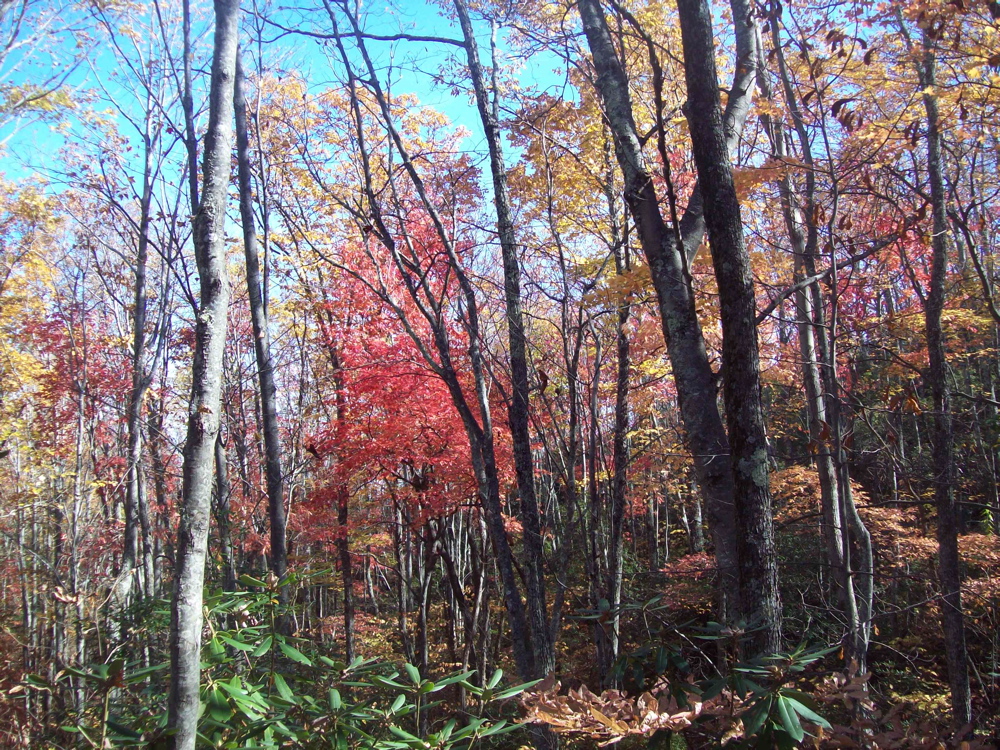
From here I retraced my steps back to the campsite to retrieve my pack, and then headed back to Cane Gap in order to jump back on to the Cooper Road trail. This section of Cooper Road trail (from Cane Gap to the junction with Beard Cane & Hatcher Mtn trails) is 1.8 miles long and gains about 500 feet in elevation. The uphill is pretty steady with just a few flat areas to give your lungs a rest. It's rarely very steep, but it gave me a workout. It was here that I saw the only other trail users of my whole trip - 3 trail runners coming down the trail as I was heading up. The trail is pretty rocky (and fairly eroded and rutted in many places) and climbs up a dry, sandy ridge that offers some nice views to the west, looking back toward Chilhowee Mountain. At about 2000 feet in elevation the fall color was starting to take hold. The dogwoods and sourwoods were turning scarlet, the sassafras orange, and the hickories and maples bright yellow.

Fall colors along Cooper Road trail; Chilhowee Mountain in the background
After what
seemed like significantly more than 1.8 miles I finally reached the junction of Cooper Road trail with the Beard Cane and Hatcher Mountain trails. Both of these trails remain closed due to downed trees that resulted from the tornado that ripped through the area last May. I stopped here for lunch and rest and pondered when these trails would be cleared.
Self-portrait at the Cooper Road - Beard Cane - Hatcher Mtn trail junction
This was the end of new trail for me on this trip. I packed up after lunch and headed back down the Cooper Road trail the 5-ish miles to Abrams Creek Ranger station and my car. Luckily, from here it really is almost all downhill and the hike out was quite pleasant. In addition to the beautiful fall colors, the New England Aster and Goldenrod were in flower all along most of the trails, and there was a lot of an interesting pale blue mushroom (some kind of
Lactarius I believe). And I ran across what I think is a wild turkey tail feather.
Turkey tail feather?
New England Aster & Goldenrod
Lactarius?
All in all it was a wonderful backpack. Fall is my favorite season for hiking, and it was luxurious to get to spend a night alone in the wilderness with a roaring fire and cool night air. I'm also happy to have gotten a few of the "dead-end" trails finished off from this section of the park. A couple more loops and I'll have the whole Cades Cove / Abrams Creek section of the park finished (assuming they ever open up Beard Cane and Hatcher Mountain trails again...).
I'm looking forward to another hike again soon. My friend Margie who's also working on doing all the trails in the park (see her blog
here) is coming over in a couple of weeks and we're going to tackle the Grapeyard Ridge Trail. So - get out there while it's still autumn and check out the fall colors!
Til next time, happy hiking!