Total Miles Hiked: 15.5
17 October 2014
Autumn is the most magical time of year in the Smokies. Any time of year in the Smokies is wonderful, but the combination of sunshine, cool temperatures, clear skies, and colorful leaves in autumn makes it unparalleled in its beauty.
The new trail miles for this hike were to be found on the Lower Mt. Cammerer trail, a 7.3 mile connector between Cosby and the Appalachian Trail in the northeastern corner of the park. To make this trek more interesting, and to get to visit one of my favorite spots in the park, I decided to make a loop out of it. I started at the Cosby campground, went up the Low Gap trail to the AT, across Mt. Cammerer on the AT, and then connected with the Lower Mt. Cammerer trail back to Cosby.

Trailhead at the hiker parking lot

Trail junction leading to either Lower Mt. Cammerer or Low Gap trail

Real beginning of the Low Gap Trail at the edge of Cosby campground
There is a maze of trails around the Cosby campground - the Cosby nature trail, side trails leading to the Lower Mt. Cammerer trail, and to the Low Gap trail. Luckily, most of the junctions have signs pointing hikers in the right direction. The trail from the hiker parking area up to Low Gap is 2.9 miles long, and gains about 2000 feet in elevation. Once you are above the campground, the trail becomes pretty relentlessly uphill. I was alone, it was early and chilly, and I had fresh legs, so I managed this section in just over an hour, which is a pretty good pace for me. As Cosby is on the north side of the ridge, this part of the hike was shaded, but as I got closer to the gap I could see the sun peeking through the trees. Given all the rain we've had over the last few weeks, the bright sunshine was welcome!

Trail junction with the Appalachian Trail at Low Gap
At Low Gap I turned left (northeast) on the Appalachian Trail, and headed up the flank of Mt. Cammerer. The AT rises a few hundred feet, and then straddles the ridge for about a mile before it meets the side trail to the Mt. Cammerer fire tower. This is my favorite kind of trail - high elevation, with great views off to either side, and the sun and the wind in my face.

View of the Mt. Cammerer ridgeline

The AT along the crest of Mt. Cammerer.
The side trail to the Mt. Cammerer fire tower is 0.6 miles long, and hugs the northern flank of the ridgeline. The fire tower itself is, I think, one of the most majestic structures in the park - in part at least because of its setting, jutting out on the very end of a knife-edge ridge at the northeastern edge of the mountain. The views from here are unparalleled, and the weather cooperated beautifully. You could see ridge upon ridge of mountains marching away to the east. The fall colors were in full force as you looked down from the tower to the flanks below. It was all orange and yellow and red.

Side trail leading to the Mt. Cammerer firetower

Mt. Cammerer firetower

View to the east from the firetower.

USGS marker - Mt. Cammerer was formerly known as both Sharp Top and White Rocks

Fall colors...

Mt. Cammerer selfie
After taking some time to soak in the views I headed back to the AT, and then down the northeastern side of Mt. Cammerer. The trail drops fairly steeply here for 2.3 miles to the junction with the Lower Mt. Cammerer trail. Trail crews have built steps into the trail here. I'm sure this helps eliminate problems with erosion, but it's rough on the knees. There is also a neat section in here where the trail hugs the side of a large rock outcrop. This must have been a sheer cliff at one time, but the CCC built a rock retaining wall to build the trail here, and it's pretty artistic as well as functional! Once I reached the trail junction I stopped for a snack before heading down onto the Lower Mt. Cammerer trail.
Curving rock wall to provide trailbed along a sheer rock outcrop.

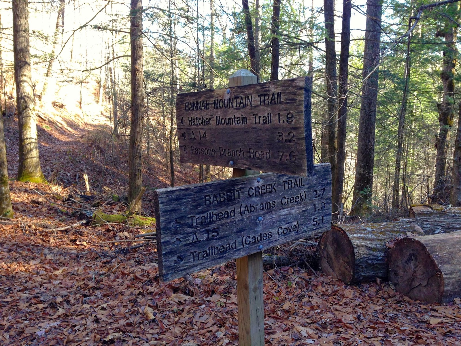
Double-blaze at the junction with the Lower Mt. Cammerer trail

Trail sign at the AT - Lower Mt. Cammerer junction
The Lower Mt. Cammerer trail is a complete contrast with the AT. While the AT went up and over the top of Mt. Cammerer with ridge top walking, the Lower Mt. Cammerer trail essentially follows a single contour line along the ridge side and weaves in and out at a nearly constant elevation. The trail here was littered with yellow leaves, and the light filtering through the trees had a pale greenish-yellow tinge. It was pleasant and easy walking, but not especially striking.

Typical section of the Lower Mt. Cammerer trail
About 1/2 way between Cosby and the AT is Backcountry Campsite #35. This site is actually divided up into a couple of subsets of campsites. Sites D & E are a ways up the hill toward the AT and are meant to accommodate horse-campers, while sites A, B & C are at the bottom of the hill near the creek, and are meant for backpackers. The upper sites (D & E) were fairly small and didn't look to have very good flat tent sites, although the fire ring looked nice and cozy. The lower sites (A, B & C) were on the flat next to the creek and looked spacious and good for tents.

Trail sign for Backcountry Campsite #35
A little over a mile from the Cosby end of the trail is a short (200 yards) side trail uphill to Sutton's Overlook. This is a flat spot on an outcrop from which you can look back toward Mt. Cammerer. It was an interesting little side-trip, but nothing to write home about.

Side trail up to Sutton Ridge Overlook

View of Mt. Cammerer from the Sutton Ridge Overlook
From here the trail winds its way back to the maze of trails around Cosby campground. I took a slightly different route back in to the campground that took me over a footbridge over Cosby Creek, and then into the campground itself.

Trail coming back in to Cosby campground

Bridge over Cosby Creek

Cosby Creek

Trail sign - back at Cosby Campground.
Back to the trailhead and my car, I finished up the 15.5 mile loop. It was wonderful to get back to the Smokies and get some more miles under my belt. I've been doing lots of hiking and backpacking lately, but more over on the Cumberland Plateau so I haven't been checking miles off of my quest to finish the trails in the park. But I'm not in any big hurry... Any day on the trail is better than a day in the office, and I've got plenty of time.
Hope you all are getting out and doing some hiking this fall to see the beautiful fall colors! Til next time, happy hiking.