Sunday, March 21, 2010

Old Sugarlands Trail

Trail Miles Completed: 3.9
Total Miles Hiked: 7.5-ish...


Sarah and I have a new tradition of spending a weekend in a cabin near the Great Smoky Mountains around our anniversary.  It began last year with our 20th anniversary and we had such a good time we vowed to do it every year.  Last year we hiked the Chimney Tops trail - it was rough, but a lot of fun.  This year I chose the Old Sugarlands Trail.  I had actually hoped to go to one of the waterfalls like Rainbow Falls or Grotto Falls, but the Cherokee Orchard Road that leads to these trailheads was closed for construction.


The trail starts just north of Sugarlands visitor center and winds its way south along the banks of the West Prong of the Little Pigeon River paralleling Newfound Gap Road, but you can neither see nor hear the road from the trail.  Sarah took this picture early on, and while it may LOOK as though I'm trying to figure out where we are, I REALLY did know...  I just have a thing for maps, and I love to look at the map as we hike along and figure out exactly where on the trail we are, or what creek we're following, etc.


The first of MANY trail junctions we came to was this one.  Our hike took us to the right along the Old Sugarlands Trail, but we eventually looped back around to this junction via the Grassy Branch trail.


This area was apparently heavily settled in the times before the park.  Horace Kephart spoke of the Sugarlands as being a wild place, full of moonshiners and ne'er-do-wells in the early 1900s.  It's named for the Sugar Maples that grow here.  The trail goes past lots of old homesteads and the location of some of the CCC camps from the 1930s.  The men in the CCC were responsible for a LOT of the park development, including trail building, fire tower construction, and bridge & road building.  The pictures below are of a marker installed in a bridge built by the CCC, and of the area where the CCC camps were.


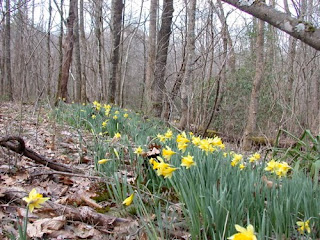
Shortly after this the trail starts to wend its way to the east, up and away from the river and along an old road bed that leads from Sugarlands to Cherokee Orchard.  The road climbs steadily, but not steeply and passes many old home sites.  You can see some of the rock foundations, boundary fences, and plants like daffodils and yuccas that were planted by the settlers.


We also passed an old boar trap.  Feral hogs are a terrible problem in the Smokies.  They destroy native vegetation and disturb the ground with their rooting, and they prey on native animals as well.  The park has an ongoing program to control the population by hunting and trapping them, but at times it seems like a losing battle.


As the trail continues to climb up to Cherokee Orchard it meets junctions with several other trails including the Twomile Lead Trail, the Twomile Branch Trail, and the Bullhead Trail.  The Twomile trails are horse trails used by folks coming up from the stables down near Sugarlands, and are not on the official park trail map, so they don't "count" in the 900 miles.  They're also hard to figure out because they're not on the maps so it's difficult to figure out exactly where they go and how long they are (hence the guesstimate of our total final mileage for the day).


Almost at the end of the Old Sugarlands trail it crosses LeConte creek, splashing down from the slopes of Mt. LeConte.  It's been a wet winter so there was lots of water in the creek and it was beautiful!  The trail crossing is over an old log bridge about 10-12 feet above the creek.


The trail dead-ends shortly thereafter at the Cherokee Orchard parking area which contains the trailheads for Trillium Gap and Rainbow Falls trails.  We could see the ongoing road construction from here.


We stopped here for lunch on a sunny rock overlooking LeConte Creek, and then turned to head back down.  Being adventurous and wanting to explore more trails I suggested we take the Twomile Branch trail back down instead of re-tracing our steps.  According to the guide book it's a shorter trip.  And maybe it is, mile-wise, but it's a rough trail.  Rocky and muddy with lots of blow-downs that have yet to be cleared.  AND, as noted above, I wasn't exactly sure how all these trails came together since they're not on the map...  We eventually made it down, and I was very happy for the excellent trail signs at all trail junctions to keep us going in the right direction.


Ultimately we used the Grassy Branch trail (which is not listed on the map OR in the book) to get us back to the beginning of the Old Sugarlands Trail.  But not without having to circumnavigate several blow-downs including this REALLY big old pine tree.


All in all it was a good hike.  It's always neat to see evidence of the people who lived here before there was a park, and imagine what their lives were like.  We also daydreamed together about a cabin that we'd love to have near the park someday...  The weather was beautiful - sunny and warm, and the companionship was excellent.  And man did it feel good to get into the hot tub at the end of the day!

Happy Hiking!

Sunday, March 14, 2010

"Strangers in High Places"

After reading Horace Kephart's "Our Southern Highlanders" I wanted to pick up the other classic book on the Smokies: "Strangers in High Places - The Story of the Great Smoky Mountains" by Michael Frome.  


Published in 1966 it provides a great complement to Kephart's book.  I borrowed a copy from our library, but you can purchase a copy here.  This is definitely another book I'll be adding to my bookshelf.


"Our Southern Highlanders" was a very personal account of Horace Kephart's life and adventures in the land that would become the Great Smoky Mountains National Park.  It describes in beautiful and humorous terms the land and the people of the area as they existed in the late 1800s / early 1900s.  


"Strangers in High Places" on the other hand is a historical account of the land and people from the early settlement of the area by whites and the natives they encountered, through the concept of the national park and the political wrangling that took place to achieve it, and finally to the current state of affairs (as they existed in the 1960s), with final notes on what Frome saw in the future for the park.  Admittedly I struggled to stay awake through parts of the book.  It is much more text-bookish than Kephart's with numerous characters who were sometimes hard to keep track of.  But it gave me a much deeper understanding of the area and the historical development of the park.  It also left me with deep respect and gratitude for some of the players in those early days...  Had it not been for folks like Arno Cammerer, Stephen Mather, Horace Albright, and John D. Rockefeller, there might very well not be a Great Smoky Mountains National Park.


Frome divides the book into two major sections: "The First Half-Billion Years" and "The Civilized Age."  The first section describes the geological history, early explorers and settlers of the area and the dealings with the Cherokee who lived here for thousands of years before white folks arrived.  The second section describes the state of the area in the early 1900s at the beginning of the push for a national park.  The politics and players, the $5 million donation of the Rockefeller foundation (approximately 1/2 of the cost of the land that makes up the park), and the residents of the park (both human and animal).  Like Kephart's book there's a lot about the moonshiners (or "blockaders" as they called themselves) and the bear hunters.


One of the chapters I enjoyed the most was chapter XXIII - For Tomorrow, a Ballad.  Here Frome muses about the 1960s pressures the park faces and contemplates its future.  He notes how the number of visitors to the park had risen substantially from 1-2 million per year in the early years of the park to projections of up to 10 million a year by the 1970s.  These projections have come true with over 10 million visitors to the park last year, more than twice as many as any other national park.  There was pressure to build more roads to allow more people to get more places in the park.  Traffic jams and car-induced smog was becoming a problem as was trash and the problems of bears becoming habituated to humans (and their food).  Some of these problems have been alleviated to a large degree.  A major educational focus on eliminating trash and keeping food away from bears has helped.


The problem of traffic congestion, however, remains a major problem.  Local wisdom says that 90% of people who visit the park never get more than 50 yards away from a road.  This saddens me because the real beauty of the Smokies lies deep in its wilderness, accessible only by trail.  Anyone who's visited Cades Cove on a Saturday in October can attest to the insane traffic and constant "bear jams" or "deer jams" that occur when people stop in the middle of the road to goggle at the wildlife.  Frome conjectures that public transportation into and around the park is something that must be introduced.  Over 40 years after Frome's book was published there's still debate about whether we could or should do this.


All in all this was an outstanding book that gave me important insights into how the Great Smoky Mountains National Park came into being.  I highly recommend it anyone with an interest in the Smokies.

Monday, March 8, 2010

Little River Trail & Cucumber Gap Trail Loop

Trail Miles Completed: 5.1
Total Miles Hiked: 6.2

It's Spring Break around here so I'm taking advantage of the free time to get some good hikes in.  Today found me on the Little River Trail and Cucumber Gap Trail near Elkmont.  Spring has been in the air the last few days and it was supposed to be warm and sunny today.  It was (mostly) warm and (occasionally) sunny out on the trail, but it was in the mid 60s when I got back home and beautifully sunny!

Elkmont is a neat area in the park.  Former logging camp and then vacation home area prior to the formation of the GSMNP in 1934.  The Little River runs right through here and there's an excellent campground where we've spent many beautiful nights.  In mid-June every year there's an astounding display of synchronously flashing fireflies.  

Today's trail starts near the Elkmont campground at the Little River trailhead.  The total trip took me up the Little River Trail to it's junction with the Huskey Gap trail, and then backtracking for about 0.4 miles to hop onto the Cucumber Gap trail which takes me back to Elkmont.


Little River trail follows the bank of the river and is a wide even path which is a former road and/or rail line used by the logging company.  Despite the warm weather there was still quite a bit of snow on the ground and parts of the trail had a thick coating of slushy ice making for some precarious hiking.


The river was beautiful as always - swollen with recent rains and melting snow it was moving pretty fast.


The trail follows the banks of the river with big rock cliffs on the right hand side and the river on the left for most of it's length.  At about mile 2.0 you cross over a plank bridge that spans Huskey Branch as it cascades into the Little River.  While a pretty small waterfall it's very picturesque, especially with the snow and ice surrounding it.


Shortly thereafter I reached the junction of the Little River and Cucumber Gap trails.  While I planned to take the Cucumber Gap trail back to Elkmont I went on the extra 0.4 miles to the Huskey Gap trail to finish off this section of the trail.


I stopped for a break and a snack at the Huskey Gap trail intersection.  The trail crosses the river over an old bridge here and there was a nice sandy bank to sit on to eat.


Back in my raft-guiding days all the guides used to build towers of rocks on the banks of the river.  The story goes that you pile up all your bad karma with the rocks and then when the river washes the rocks away it takes your bad karma with it.  I guess old habits die hard :-)  And I took it as a good sign that as soon as I finished my little tower the sun came out.


Here's the view upstream of where I sat to eat lunch.


After lunch I headed back down to jump onto the Cucumber Gap trail.  This trail is more typical of the Smokies.  A "long, green tunnel" of rhododendron and hemlock trees and the floor of the trail twining with tree roots and jutting rocks.  There was considerably more snow here as I was moving up in elevation through a narrow shaded draw.


This trail winds up a draw and then up and over Cucumber Gap - named for the Magnolias ("cucumber trees") that grow there, and then back down into Elkmont.  Here in the gap I met a trio of backpackers who were on Spring Break from the University of Connecticut.  They had driven 14 hours from CT down to Knoxville to spend the week backpacking in the Smokies.  Not sure they were expecting this much snow and they were planning to go up high to the Appalachian Trail where the snow is probably still 1-2 feet deep!  (we, of course, got into a heated debate about who was more likely to win the women's basketball NCAA tournament, UConn or the Lady Vols)


From Cucumber Gap the trail drops back down into Elkmont and dumps out at the Jake's Creek trailhead just up from Elkmont.


Here in Elkmont you can see the remains of many of the cabins that made up the summer vacation homes for wealthy folks.  While the park was formed in 1934 apparently the leases on the property for these homes didn't expire until 1992, and they've been in limbo ever since.  Some folks wanted them preserved as they were as an exhibit of what life was like in the early 1900s, while others wanted them torn down so the land could return to it's natural state.  I believe that the park system has finally decided to renovate some of the older historic cabins and remove the others.  Interestingly most of the cabins are in terrible shape - sagging porches and caved in roofs; but some of the older log cabin building are still solid and in fairly good shape.


It was a beautiful day to be out and a great way to spend my first day of spring break.  This is a great loop of reasonable length for a day hike.  Great scenery that ranges from rivers to rocks to waterfalls to historic cabins.

Til next time - happy hiking!

Sunday, March 7, 2010

Crib Gap Trail

Trail Miles Completed: 1.6
Total Miles Hiked: 4.0


So...  it was Sunday afternoon.  I was full from a big lunch.  The kids were happily watching TV and playing video games.  We were all resting and relaxing.  What's wrong with that on a Sunday afternoon, right?  So why did I feel guilty slugging the day away?  Probably because it was a beautiful day, warm and sunny with spring in the air, and I just couldn't succumb to the sluggardliness.


So I grabbed my Smokies map and looked for a short trail that was relatively close that we could get to and hike in just a few hours.  Voila - the Crib Gap Trail!  This is a short (1.6 miles) trail that connects the Turkeypen Ridge Trail with the Anthony Creek Trail that leads into Cades Cove.  Jesse and I had done the Turkeypen Ridge trail on a previous hike, but I've never been on this little connector.  I collected Duncan (my youngest son, 9 years old) and said "You wanna go for a hike?"  He turned off the Wii in a flash and had his boots on ready to go in just a couple of minutes.  He doesn't care where we're going, or if there's going to be scenery or impressive waterfalls - he just wants to go :-)


The trailhead for this hike is right on Laurel Creek Road in between the Townsend Y and Cades Cove.  Traffic was light today because the Cades Cove loop is closed for repaving for the next couple of months.  We were at the trailhead in 45 minutes and ready to go.


To get to the Crib Gap Trail you have to go north on the Turkeypen Ridge Trail for 0.2 miles.  From there the Crib Gap Trail heads pretty much due west towards Cades Cove.


To be brutally honest there's nothing special about this trail compared to the rest of the Smokies.  It winds through hemlock-rhododendron woods and up over Crib Gap and then down through a drier pine-laurel forest towards Cades Cove.  There's no beautiful creek to follow, no outstanding views, no huge rocks to climb...  BUT, to say "there's nothing special" when you're in the Smokies is an oxymoron - it's ALL special.  And it's even better when you have someone to share it with like a 9-year old who can't stop saying "it's so beautiful here!"


There was a little bit of snow left on some of the shadier banks, but most of it had melted and much of the trail was a muddy mess.  This trail is apparently frequented by horses which tears up the trail pretty badly when it's wet.


The Crib Gap trail ends at its intersection with the Anthony Creek Trail that leads south out of the Cades Cove picnic area and up to the ridge line and Appalachian Trail.  We took the extra 0.2 miles down to the picnic area for a snack and a break.


There's nothing quite like sitting on a big rock in the middle of Anthony Creek eating licorice...


By now it was around 4:30 pm and likely to get dark soon so we turned around and headed for home.  The return trip was uneventful other than a few extra stops to rest a pair of weary little legs.  As we approached the trail head I convinced Duncan to walk an extra 0.2 miles to go see the trail that leads UNDER Laurel Creek Road.  This is a short trail that connects the Turkeypen Ridge Trail on one side of the road to the Finley Cane Trail on the other side.  And yes - this really is the trail, even though it looks more like a creek.


This coming week is spring break at UT, so I will be taking at least one more hike soon.  Planning to do the Little River Trail - Cucumber Gap Trail loop tomorrow, so look for another update soon.

Happy Hiking!