Saturday, June 25, 2011

Brushy Mountain summit via Trillium Gap Trail

Trail Miles Completed: 2.1
Trail Miles Hiked: 6.6
25 June 2011

A group of guys from church do hiking trips once in a while and this weekend we had a trip to Brushy Mountain planned.  Up early and at the Grotto Falls parking area by 7 am!  On the way in we saw a young black bear ambling across Cherokee Orchard Road.  And then as we were getting ready to hit the trail we saw another black bear down by the garbage cans at the other end of the parking area.  This one was BIG, and didn't seem at all perturbed to find mere humans in his domain.  In fact, he apparently found us quite interesting...


After rattling the lid on the garbage can trying (unsuccessfully) to get it open he wandered over toward us.  He was getting closer and closer and we were about to jump into the cars when he decided to turn down into the woods.  Phew - nothing like a close encounter of the bear kind to get your blood pumping early in the morning!

Here's our crew getting ready to hit the trail: Greg, Duncan, Emery, Jack & Brad

We headed up Trillium Gap trail and made good time up to Grotto Falls.  This early in the morning the light was dim and misty and the falls had an ethereal quality to them.  We took the required pictures of folks behind the falls :-) and then headed on up the trail.

Duncan & Emery behind the falls.

Trillium Gap trail between Grotto Falls and Trillium Gap is a nice winding trail, in places flat and sandy and in other places rocky and tree root-laced.  It moves continually up, but relatively gently and is never really steep.  It winds through some nice big old trees and often crosses or follows creeks so it's a very pleasant trail.

Trail sign at Trillium Gap.  We were taking the Brushy Mountain trail up the summit of Brushy Mtn.

Trillium Gap apparently used to be called Grassy Gap, which is a much more apt name.  It's a saddle between Brushy Mountain and one of the lower ridges of Mt. LeConte and is full of grass, but apparently devoid of Trilliums.  Regardless, it's a pleasant spot to sit and rest a few minutes before tackling the last 0.4 miles up to the summit of Brushy Mtn.

As the trail climbs up toward the summit of Brushy Mtn. the plants change dramatically.  At Trillium Gap we see some spruce trees starting to appear.  On the dry hike up Brushy Mtn. the trail is lined with Mountain Laurel and Galax (both still in flower at this higher elevation) and some unusual higher elevation species start to appear.  These include Sand Myrtle and Rugel's Ragwort, the latter a Smoky Mountain endemic species found only at higher elevations.  The top of Brushy Mtn. is devoid of trees and instead covered with laurels, rhododendrons and sand myrtle.  This allows some fantastic views around all sides.  To the north we could see Pigeon Forge, to the east Greenbrier Pinnacle and to the west the lower ridges of LeConte.


We stopped here for lunch and took in the amazing views.  Definitely a place worth visiting - I think I'll have to come back here for a view of the trees in the fall.

Heading back down was considerably easier simply because it was all down.  The boys did a good job coming up the trail although it taxed their stamina at some points.  On the way back they were again full of energy.  We stopped again at Grotto Falls so they could climb and jump on the rocks and play in the water.  By now (about 2 pm) the falls were packed with people.
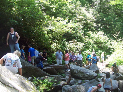

And they were also beautiful in the sunshine!


This was a really nice hike overall.  The weather today was perfect - cool temperatures, yet sunny.  Getting an early start was great since we missed the throngs of people on our way up the trail and had the falls nearly to ourselves the first time we passed them.  The trail is in good shape for most of the way and has interesting plants, creeks and views.  The hike up Brushy Mtn. was really nice - fantastic views and cools plants.  Definitely someplace to go back to!

Til next time, happy hiking!

Wednesday, June 22, 2011

Baskins Creek and Trillium Gap Trails Loop

Trail Miles Completed: 5.0
Trail Miles Hiked: 7.9
21 June 2011

Happy Summer Solstice!  The beginning of summer seemed like a great excuse to go for a hike, so I headed down to Gatlinburg to the Cherokee Orchard / Roaring Fork area.  Given that it was the longest day of the year I figured I'd have a little extra daylight and didn't leave my house until about 5 pm.  What I forgot to take into account is Sevierville/Pigeon Forge/Gatlinburg traffic...  I didn't get to the trailhead until almost 7 pm!  Undaunted I forged ahead.  My loop started at the lower trailhead for Baskins Creek Trail (on Roaring Fork) and went up Baskins Creek trail to Cherokee Orchard where I hopped onto Trillium Gap trail.  I did the 0.7 mile section to the west (junction w/ Rainbow Falls trail) and then back again and continued on to the east to the Grotto Falls parking area, and then road-walked back down to my car.


The Baskins Creek trail is very nice, and at 2.7 miles in length, a very reasonable hike.  Baskins Creek Falls is roughly in the middle, and is at the lowest point on the trail, so either way you go in you're going to go down and then back up.  I started at the Roaring Fork end, and just a little ways in you pass an old cemetery with a sign that says it's being renovated.  The signs that say it's being renovated look like they need to be renovated, so I'm guessing this has been going on for a while...


The trail passes through prototypical Smokies deep, dark forest (I kind of felt like I was in Fangorn Forest in Middle Earth).  It's dark and damp, the trail lined with rhododendron and hemlock.  The Rosebay Rhododendron are just about at their peak right now, so I was walking under a ceiling of flowers and on a carpet of fallen flowers.  Absolutely gorgeous!


The side trail to Baskins Creek Falls appears about mid-way through the hike.  I'd guess it's about a quarter mile from the main trail down to the falls, with the last little bit being very steep and rocky down to the base of the falls.  The falls themselves are impressive - there is a very wide rock rim with the falls spilling over one little section into a rocky pool at the base.  A salamander was sitting on a rock looking at me when I arrived, but unfortunately he dove for the water as soon as I reached for my camera.  This would be a lovely spot for a picnic on a hot summer afternoon.


From Baskins Creek Falls the trail steadily gains elevation on its way up toward Cherokee Orchard.  The trail follows Falls Branch much of the way, and there are some really pretty little cascades and cool rock shelters along the trail as well.  Along the way there is another side trail, this one leading to Baskins Creek Cemetery.  About a quarter mile hike takes you up to a small clearing with a dozen or so graves, almost all of them marked with roughly shaped pieces of slate as gravestones.  While you can make out some writing on some of them, they are all so worn that they are illegible.


As the trail nears the top it comes out on a drier side of the ridge and the mountain laurels abound.  There are some nice views here out toward Mt. LeConte and points further west.  The trail ends at Cherokee Orchard Road, and I arrived at about 8:30.  It was starting to get fairly twilightish by now - a combination of the late hour and the clouds.


From here I took the little spur trail that connects Baskins Creek trail with Trillium Gap trail.  I took the Trillium Gap trail west 0.7 miles to its junction with Rainbow Falls trail, and then turned around and headed back up Trillium Gap to its junction with the spur trail that leads down to Roaring Fork Road at the Grotto Falls parking area.  This particular section of the Trillium Gap trail parallels Roaring Fork Road and is not often used during the summer.  But it's a nice trail - fairly level with just a few ups and downs, and the trail is remarkably flat and generally free of rocks and tree roots.  Which is a good thing, since by now it was getting full dark and I was still hiking.  At one point the winds started howling and rushing through the trees - a pretty amazing feeling to be hiking through!  Ultimately the rain started in, but luckily not terribly hard, nor for very long.  I discovered (happily) that my rain coat is big enough to cover both me and my daypack, which is a good thing since I didn't bring my pack cover.

About a half mile from the Grotto Falls parking area I finally had to dig out my head-lamp - it was so dark under the trees that I couldn't even pretend I could see the trail anymore.  So I finished the hike up via head-lamp and made it safely back to Roaring Fork Road.  The evening finished up with a 1.2 mile road walk back down to my car.

All in all it was a neat hike.  Baskins Creek Falls and the Baskins Creek Cemetery are both well worth a visit, and the Baskins Creek trail in general is quite nice.  Plus I got to finish off the lower section of Trillium Gap trail to complete the loop and I was surprised at how pleasant a walk it was.  I'll be back in this area soon - going up Trillium Gap trail to Brushy Mountain with some friends from church on Saturday!

Til next time, happy hiking!
(and don't forget your raincoat and headlamp)

Saturday, June 4, 2011

Gregory Ridge and Gregory Bald trails

Trail Miles Completed: 12.3
Trail Miles Hiked: 17.3
3-4 June 2011

I've always heard amazing things about Gregory Bald while the Flame Azaleas are flowering. This weekend was unexpectedly free, so I called my buddy Shane who was game to join me for a backpack.  It's a little early in June for the azaleas to be flowering (they're usually at peak about the 3rd week of June), but I was hoping that since we've had an early spring they'd already be started.


We started at the Gregory Ridge trailhead at the end of Forge Creek Rd in Cades Cove.


The first mile or so gains elevation, but fairly gently, until it reaches Campsite #12. This is a fairly nice site - right near a creek and with a nice fire ring area, but not too many good tent sites, and the best one is right next to the fire ring and bear cables.  Might be good for a small group.  There is an upper tenting / fire ring area too, but a lot of downed trees up there.


From Campsite #12 the trail immediately climbs a steep ridge over to the west side of Gregory Ridge and stays steep the rest of the way up (it's about 5 miles from the trailhead to the junction with Gregory Bald trail). We were huffing and puffing all the way up, and made many more rest stops than I'd care to admit. In the upper reaches of the Gregory Ridge trail we started seeing a lot of flame azalea and mountain laurel in flower - they were absolutely gorgeous!  The trail is in pretty good shape despite its steepness.  There is one area where it's fairly badly rutted, but for the most part it was good trail.


We reached the junction of Gregory Ridge trail with Gregory Bald trail and decided to spend an extra hour or so to do the 2 miles of the eastern end of Gregory Bald trail out to Doe Knob on the A.T.  This is a nice little trek that meanders up and down - there were lots of flame azalea and mountain laurels on this trail in full flower.


Reaching the junction of the Gregory Bald trail and A.T. made another connection for me.  I had hiked the A.T. from Newfound Gap down to Fontana Dam about 9 years ago - one of my very first long-distance backpacks in the park.  It was cool to come back to this place and know that I had been here before.


From here we turned back around up the Gregory Bald trail up to Gregory Bald itself.  The 0.6 miles from the Gregory Ridge - Gregory Bald trail junction up to the bald itself were rough - partly because it's pretty steep, but mostly because we'd already hiked 9 miles, most of them uphill...  But it was SO worth it.  Gregory Bald is an amazing place - covered with blueberry bushes, blackberry brambles and flame azaleas.  A few of the flame azalea were flowering, but you could see the buds on all of them - in a week it will be an amazing carpet of yellow-orange-red flowers!


The trail goes straight across the top of the bald, and there are gorgeous views in all directions.  We were there late in the afternoon and the sun was slanting downwards giving everything a warm glow.  Unfortunately in the throes of exhaustion and wonder I forgot to take any panoramic pictures...  But trust me - it's well worth the climb.  We found the USGS marker at the top: 4,949 feet!


And also got to see a deer amble across the bald.  She knew we were there, but didn't seem perturbed.


After soaking in the views for a while we headed down over the other side of the bald about 0.5 miles down to Campsite #13.  This is a beautiful campsite.  You have to make a reservation to camp there since it's heavily used, but it's really nice.  It's in a fairly level area, and there are about 4 or 5 tent sites, all nicely spaced so every group can have some privacy.  There were deer wandering all through the campsite for most of the evening, and a herd of them woke Shane up in the middle of the night.


After setting up camp we ate and chatted the night away, finally getting to bed around 11 pm.  In the morning we were up and around by about 7 am, had breakfast and broke camp.  We were both a little stiff and sore from the day before, but that quickly wore off.  Campsite #13 sits at the junction of Gregory Bald trail and the Wolf Ridge trail which comes up from the North Carolina side of the park around Twentymile.


We continued on the Gregory Bald trail which terminates at Parson Branch road. Parson Branch roads leads one-way out of Cades Cove and dumps out on U.S. 129 on "the dragon" (318 curves in 11 miles).  We turned down Parson Branch and back to the trailhead - about a 3 mile road walk.  This is the trail marker sign for Gregory Bald trail at its junction with Parson Branch road.


Along the way down we saw many nice plants still in flower including some mountain laurel in full flower.  This is one of my favorite flowers - my sweet daughter Laurel is named after it.


There are some big trees in this section - I can imagine it would have been very difficult to log up in the upper reaches of this area given how steep the terrain is.  Here's Shane standing by a really big old tulip poplar.


We arrived back at the car around noon, tired out but happy.  This was a very challenging hike, but very well worth the effort to see Gregory Bald.  Some day I'll have to go back at the right time to see all of the flame azaleas out in full flower on the bald and spend some time just lazing among them.

Til next time, happy hiking!

Friday, May 6, 2011

Ramsey Cascades Trail

Trail Miles Completed: 4.0
Trail Miles Hiked: 8.0
6 May 2011

There seems to be some debate about the spelling of this trail name.  The little brown book and old maps have it as "Ramsay," while the new maps and the park service sign have it as "Ramsey."  Some info suggests that it is named for the Ramsey family that lived in the area, so I'm going to go with that spelling...


Things at school are winding down for the semester - classes are over and it's finals week so I have a little flexibility with my time.  My buddy Shane works four ten-hour days and so has most Fridays off and he was game to come along with me today.


The Ramsey Cascades trail is in the Greenbrier section of the park and leads to one of the tallest waterfalls in the park.  For most of its length the trail parallels either the middle prong or the Ramsey prong of the Little Pigeon River.  With the wet spring we've had the river was running strong.

While wildflower season is starting to wind down, there were still several nice flowers out along the trail.

Foam flower 

Clinton's Lily  or Speckled Wood Lily 

Bluets

Red Elderberry

For the first 1.5 miles the trail follows an old road, and while it gains elevation slowly and steadily it's quite an easy trek.  From the 1.5 mile point on, the trail becomes steeper, rockier and the footpath laced with tree roots.  But it's a beautiful trail!  Because it follows the river you can always hear the rushing of water, and the trail passes through and around some huge boulders, especially as you get closer to the cascades.  AND - this part of the trail is true old-growth forest - never been logged.  These are some of the biggest trees I've ever seen in the park.

Shane on the trail as it passes between two ginormous Tulip Poplars

The falls themselves are amazing!  The area around the falls is all big boulders piled on top of each other, and the falls are almost 100 feet high.  There was a fair amount of water coming over them and there are great rocks to sit on or climb around on.  We stopped for lunch and chatted with a very friendly guy who had gotten there just a little while before we did.


Before we set out on this hike I read several other folks' accounts of this trail.  They ALL mentioned the danger of trying to climb up the falls and that at least four people have died here.  The park service clearly wants to drive home that point...


After taking some time to lunch and lounge we explored the area around the falls and then headed back down the trail.  It was considerably easier going down (it's about a 2000 ft elevation gain from the trailhead to the falls) and with the sun out, the river rushing and the good company it flew by.

This is definitely a trail I will go back to some day.  It's challenging enough to be interesting, but not so challenging as to be intimidating.  The trail itself is beautiful and the huge rocks and trees just made it even better.  The Ramsey Cascades are well worth a visit.  All in all, another great day in the Smokies!

til next time, happy hiking!

Friday, April 22, 2011

Finley Cane - Bote Mountain - Lead Cove trails

Trail Miles Completed: 5.7
Trail Miles Hiked: 9.5
22 April 2011

This loop has been on my list to do for quite a while, and today was "Spring Recess" (aka Good Friday) at school so I took the day to go hiking.  Out of bed at 7, in the car a little after 8, and at the trailhead a little before 9.


I did the Finley Cane trail a few years ago with Jesse on another loop, but I needed to do the Bote Mtn trail (up to Anthony Creek tr) and Lead Cove trail to help finish off this section.


Finley Cane trail starts at Laurel Creek Road about 3/4 of the way from the Townsend Y to Cades Cove.   This particular spot has the trailheads for Finley Cane, Lead Cove, Crib Gap and Turkeypen Ridge trails.  Going up the Finley Cane and connecting to the Bote Mtn and Lead Cove trails makes for a good loop hike.

Finley Cane trail is a very nice easy 2.8 mile trail that winds up and down through beautiful Smokies forest.  The total elevation gain is only 200 feet, and it's never steep. This time of year it's an amazing carpet of wildflowers.  There are huge patches of dwarf crested iris, several different Trillium species, more Squawroot than I've ever seen anywhere in the park, and dozens of other spring wildflowers, not to mention the flowering dogwood, silverbells and magnolias.


It's also both a horse and hiking trail, and the trail was in pretty rough shape from the horses (not to mention the ever present piles of horse crap).  But it's a really pretty trail with several small stream crossings.


About 2 miles in there's a wide spot in the trail where horse folks can tie up their horses and take a break, so I decided to as well.


The Finley Cane trail dead-ends into the Bote Mountain trail.  Stepping onto the Bote Mtn trail the atmosphere immediately changes.


While Finley Cane wends its way through rich woodlands, the Bote Mtn trail is a dry ridge-side walk up along the eastern edge of Bote Mountain.  The trail was originally a road used to reach Spence Field at the crest of the Smokies, presumably to graze cattle in the open meadows at the top of the ridge.  The little brown book tells how the Cherokee workers who were helping to build the road chose this ridge rather than the one further east for the road, but since they couldn't say the letter V they "boted" for this ridge, hence its name.  The alternative ridge became known as Defeat Ridge.

The section of Bote Mtn trail between Finley Cane and Anthony Creek trails is about 3.7 miles long but has 3 distinct sections.  The first mile is unrelentingly uphill and it about kicked my butt.  Luckily there were several great places to stop and look across the valley to Defeat Ridge so I had a good excuse to stop and rest.


The middle 1.5 miles is a nice ridge-top stroll with relatively little elevation change - just some meandering up and down.  The final 1.2 miles (from the Lead Cove trail junction up to the Anthony Creek trail junction) goes back to tough uphill slogging (and presumably the final 1.7 miles of the trail up to the A.T. are also pretty steep).  I enjoy seeing the different kinds of trails in the Smokies.  Finley Cane is dark and damp and the soil is rich and loamy.  Bote Mountain on the other hand is dry, rocky and sandy due to the underlying sandstone and the lack of appreciable accumulation of organic material.


The next waypoint on the trail is the junction with the Lead Cove trail which would be my path back down to my car after I went the 1.2 miles up to the Anthony Creek trail junction.


As I was approaching this intersection I was startled out of my reverie by a doe jumping across the trail not more than 5 feet in front of me - apparently I startled her as much as she startled me!  She didn't go far though, so after I settled down to watch she tentatively came back up on to the trail and let me get her picture.


I stopped for a snack and a drink here before heading the last 1.2 miles UP to the Anthony Creek trail junction.


The wildflowers were very nice along this section of the trail too, with more big patches of dwarf crested iris and a variety of other spring ephemerals.  I finally reached the Anthony Creek trail junction and stopped for lunch.


It was all downhill from here.  I retraced my steps back down to the Lead Cove trail and turned down back toward Laurel Creek Road and my car.  This trail is not long (~ 1.8 miles) but is steep (1200 foot elevation change) so I was happy to be going down instead of up.  Lead Cove trail was also graced with beautiful wildflowers, small creek crossings and beautiful trees.  More Trilliums, Violets, Dogwoods and Magnolias.

At one point the trail skirted a recent blowdown - the root ball of the tree was so big that when it went down it took a chunk of the trail with it.


About 1:30 I made it back to the trailhead and my car.  I finished the 9.5 miles in about 4.5 hours which included LOTS of wildflower watching and photographing and snack breaks.  All in all it was a fantastic day to be out in the park, and the wildflowers were amazing!  I especially recommend the Finley Cane trail for wildflowers - it's got a lot of diversity and is an easy and pleasant trail.


I plan to go back to this area soon - I want to do the Anthony Creek - Russell Field - A.T. - Bote Mtn - Anthony Creek trails loop as an overnight backpacking trip.  I love getting up high in the Smokies and spring is a great time to be out.

til next time, happy hiking!